IMAGES TAKEN NEAR TO
Tythings Court, MINEHEAD, TA24 5NT
Introduction
This page details the photographs taken nearby to Tythings Court, TA24 5NT by members of the Geograph project.
The Geograph project started in 2005 with the aim of publishing, organising and preserving representative images for every square kilometre of Great Britain, Ireland and the Isle of Man.

There are currently over 7.5m images from over14,400 individuals and you can help contribute to the project by visiting https://www.geograph.org.uk
Image Map
Images are licensed for reuse under creativecommons.org/licenses/by-sa/2.0
Notes
- Clicking on the map will re-center to the selected point.
- The higher the marker number, the further away the image location is from the centre of the postcode.
Image Listing (451 Images Found)
Images are licensed for reuse under creativecommons.org/licenses/by-sa/2.0
Image
Details
Distance
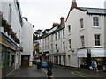
4
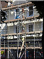
Removing the scaffolding
In Park Street, Minehead.
Image: © John Lucas
Taken: 15 Jul 2019
0.02 miles
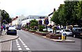
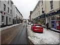
5
Looking down Holloway Street from The Parks
Image: © Basher Eyre
Taken: 5 Aug 2008
0.02 miles
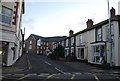
6
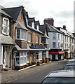
The Queens Head Inn, Minehead
Located on the corner of Holloway Street and Market House Lane. The queen in question is Elizabeth I.
Image: © Jaggery
Taken: 21 Mar 2010
0.02 miles

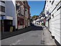
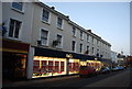
10
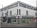
Former Blockbuster outlet, Minehead
Was an early victim of the company's failure, having closed some months previously. Standing at the junction of Park Street and Holloway Street, this ugly commercial building replaced a lovely old coaching inn - the Plume of Feathers; demolished in 1965.
Image: © Roger Cornfoot
Taken: 17 Jan 2013
0.03 miles