IMAGES TAKEN NEAR TO
King George Road, MINEHEAD, TA24 5JD
Introduction
This page details the photographs taken nearby to King George Road, TA24 5JD by members of the Geograph project.
The Geograph project started in 2005 with the aim of publishing, organising and preserving representative images for every square kilometre of Great Britain, Ireland and the Isle of Man.

There are currently over 7.5m images from over14,400 individuals and you can help contribute to the project by visiting https://www.geograph.org.uk
Image Map (Loading...)


Getting Data...Please wait
Leaflet Map data © OpenStreetMap
Images are licensed for reuse under creativecommons.org/licenses/by-sa/2.0
Notes
- Clicking on the map will re-center to the selected point.
- The higher the marker number, the further away the image location is from the centre of the postcode.
Image Listing (129 Images Found)
Images are licensed for reuse under creativecommons.org/licenses/by-sa/2.0
Image
Details
Distance
1
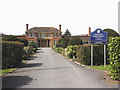
Entrance driveway, Minehead Middle School
Image: © Roger Cornfoot
Taken: 9 Apr 2010
0.06 miles
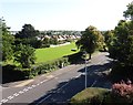
2
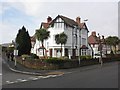
Kingsway Hotel, Ponsford Road, Minehead
Image: © Roger Cornfoot
Taken: 2 Feb 2014
0.06 miles
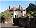
4

Police station and former magistrates court, Minehead
Image: © Roger Cornfoot
Taken: 26 Dec 2010
0.08 miles

8
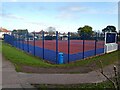
Sports court at Minehead Middle School
Image: © Roger Cornfoot
Taken: 7 Jan 2021
0.10 miles
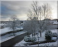
9
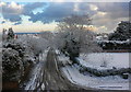
King Edward Road, after a night's snowfall
Image: © Roger Cornfoot
Taken: 18 Dec 2010
0.10 miles
10

King Edward Road in early March 2018
Image: © Roger Cornfoot
Taken: 2 Mar 2018
0.10 miles