IMAGES TAKEN NEAR TO
Dugdale Street, MINEHEAD, TA24 5EH
Introduction
This page details the photographs taken nearby to Dugdale Street, TA24 5EH by members of the Geograph project.
The Geograph project started in 2005 with the aim of publishing, organising and preserving representative images for every square kilometre of Great Britain, Ireland and the Isle of Man.

There are currently over 7.5m images from over14,400 individuals and you can help contribute to the project by visiting https://www.geograph.org.uk
Image Map (325 Images)


Getting Data...Please wait
Leaflet Map data © OpenStreetMap
Images are licensed for reuse under creativecommons.org/licenses/by-sa/2.0
Notes
- Clicking on the map will re-center to the selected point.
- The higher the marker number, the further away the image location is from the centre of the postcode.
Image Listing (325 Images Found)
Images are licensed for reuse under creativecommons.org/licenses/by-sa/2.0
Image
Details
Distance
1
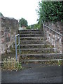
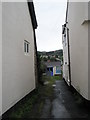
Steps from Dugdale Alley up into Millstream Close
Image: © Basher Eyre
Taken: 5 Aug 2008
0.01 miles
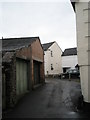
6
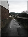
Alleyway between Dugdale Road and Court Green
Image: © Basher Eyre
Taken: 5 Aug 2008
0.03 miles
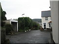
8
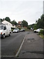
Dugdale Street
A residential cul-de-sac.
Image: © Bill Boaden
Taken: 1 Jul 2017
0.03 miles
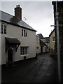
9
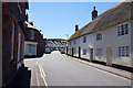
Bampton Street, Minehead
Rows of cottages, some thatched, very close to the town centre.
Image: © Bill Boaden
Taken: 1 Jul 2017
0.05 miles
10
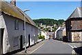
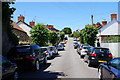
Bampton Street, Minehead
Heading towards the town centre. St Michael's Church is very prominent on the hillside ahead.
Image: © Bill Boaden
Taken: 1 Jul 2017
0.05 miles