IMAGES TAKEN NEAR TO
WATCHET, TA23 0UA
Introduction
This page details the photographs taken nearby to TA23 0UA by members of the Geograph project.
The Geograph project started in 2005 with the aim of publishing, organising and preserving representative images for every square kilometre of Great Britain, Ireland and the Isle of Man.

There are currently over 7.5m images from over14,400 individuals and you can help contribute to the project by visiting https://www.geograph.org.uk
Image Map (Loading...)


Getting Data...Please wait
Leaflet Map data © OpenStreetMap
Images are licensed for reuse under creativecommons.org/licenses/by-sa/2.0
Notes
- Clicking on the map will re-center to the selected point.
- The higher the marker number, the further away the image location is from the centre of the postcode.
Image Listing (3 Images Found)
Images are licensed for reuse under creativecommons.org/licenses/by-sa/2.0
Image
Details
Distance
1
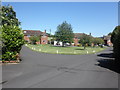
Housing estate, at the eastern edge of Watchet
Image: © Roger Cornfoot
Taken: 19 Jul 2012
0.04 miles
2
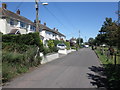
Road through housing estate, to the east of Watchet
Image: © Roger Cornfoot
Taken: 19 Jul 2012
0.19 miles
3
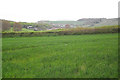
Towards Doniford
Taken from the Watchet - Williton footpath/cyclepath. The former Liddimore Married Quarters housing estate (for the now defunct Doniford Camp) is in the middle ground, with Doniford hidden beyond. East Quantoxhead is the furthest point on the horizon.
Image: © Stephen Wilks
Taken: 5 May 2010
0.23 miles