IMAGES TAKEN NEAR TO
Luxborough, WATCHET, TA23 0SX
Introduction
This page details the photographs taken nearby to TA23 0SX by members of the Geograph project.
The Geograph project started in 2005 with the aim of publishing, organising and preserving representative images for every square kilometre of Great Britain, Ireland and the Isle of Man.

There are currently over 7.5m images from over14,400 individuals and you can help contribute to the project by visiting https://www.geograph.org.uk
Image Map (Loading...)


Getting Data...Please wait
Leaflet Map data © OpenStreetMap
Images are licensed for reuse under creativecommons.org/licenses/by-sa/2.0
Notes
- Clicking on the map will re-center to the selected point.
- The higher the marker number, the further away the image location is from the centre of the postcode.
Image Listing (5 Images Found)
Images are licensed for reuse under creativecommons.org/licenses/by-sa/2.0
Image
Details
Distance
1
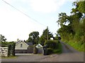
Cottages on the western slope of Croydon Hill
Image: © David Smith
Taken: 8 Sep 2015
0.02 miles
2
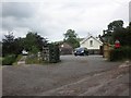
Cottages, to the west of Croydon Hill
Image: © Roger Cornfoot
Taken: 3 Jul 2013
0.02 miles
3
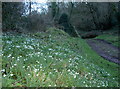
Snowdrops by the stream
Some seasonal blooms by the old stone building that once was part of Clicket village.
Image: © Neil Owen
Taken: 24 Feb 2016
0.22 miles

5
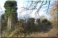
Ivy covered remains of Thorn Farm, Clicket
The remains of the long lost village of Clicket hide in the secret heart of the hills between Timberscombe and Luxborough
Image: © Ian Wigley
Taken: 10 Feb 2008
0.24 miles