IMAGES TAKEN NEAR TO
Roadwater, WATCHET, TA23 0RF
Introduction
This page details the photographs taken nearby to TA23 0RF by members of the Geograph project.
The Geograph project started in 2005 with the aim of publishing, organising and preserving representative images for every square kilometre of Great Britain, Ireland and the Isle of Man.

There are currently over 7.5m images from over14,400 individuals and you can help contribute to the project by visiting https://www.geograph.org.uk
Image Map (Loading...)


Getting Data...Please wait
Leaflet Map data © OpenStreetMap
Images are licensed for reuse under creativecommons.org/licenses/by-sa/2.0
Notes
- Clicking on the map will re-center to the selected point.
- The higher the marker number, the further away the image location is from the centre of the postcode.
Image Listing (28 Images Found)
Images are licensed for reuse under creativecommons.org/licenses/by-sa/2.0
Image
Details
Distance
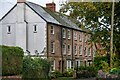
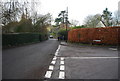
2
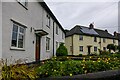
Old Cleeve : Roadwater - The Crescent
Houses in Roadwater.
Image: © Lewis Clarke
Taken: 28 Oct 2023
0.03 miles
5
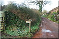
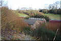
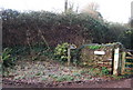
Footpath off the track to Roadwater Farm
Image: © N Chadwick
Taken: 28 Dec 2009
0.06 miles
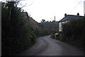
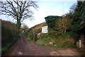
6
Old Cleeve : Roadwater - Manor Mills
Looking towards houses alongside the road.
Image: © Lewis Clarke
Taken: 28 Oct 2023
0.08 miles
8

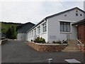
Old Cleeve : Roadwater - Singer Instruments
A business based on Church Street.
Image: © Lewis Clarke
Taken: 28 Oct 2023
0.09 miles