IMAGES TAKEN NEAR TO
Washford, WATCHET, TA23 0NL
Introduction
This page details the photographs taken nearby to TA23 0NL by members of the Geograph project.
The Geograph project started in 2005 with the aim of publishing, organising and preserving representative images for every square kilometre of Great Britain, Ireland and the Isle of Man.

There are currently over 7.5m images from over14,400 individuals and you can help contribute to the project by visiting https://www.geograph.org.uk
Image Map (Loading...)


Getting Data...Please wait
Leaflet Map data © OpenStreetMap
Images are licensed for reuse under creativecommons.org/licenses/by-sa/2.0
Notes
- Clicking on the map will re-center to the selected point.
- The higher the marker number, the further away the image location is from the centre of the postcode.
Image Listing (68 Images Found)
Images are licensed for reuse under creativecommons.org/licenses/by-sa/2.0
Image
Details
Distance
2
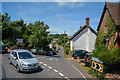
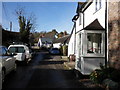
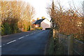
Washford : Station Road A39
Huish Lane joins Station Road.
Image: © Lewis Clarke
Taken: 12 Jul 2019
0.05 miles
3
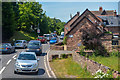
Washford : Station Road A39
Looking along Station Road.
Image: © Lewis Clarke
Taken: 12 Jul 2019
0.10 miles
5
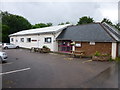
Washford Memorial Hall, Somerset
Washford Memorial Hall commemorates those from the village who fell in the Great War. It is located in Huish Lane.
Image: © John C
Taken: 15 Jun 2016
0.12 miles