IMAGES TAKEN NEAR TO
Washford Hill, WATCHET, TA23 0NA
Introduction
This page details the photographs taken nearby to Washford Hill, TA23 0NA by members of the Geograph project.
The Geograph project started in 2005 with the aim of publishing, organising and preserving representative images for every square kilometre of Great Britain, Ireland and the Isle of Man.

There are currently over 7.5m images from over14,400 individuals and you can help contribute to the project by visiting https://www.geograph.org.uk
Image Map
Images are licensed for reuse under creativecommons.org/licenses/by-sa/2.0
Notes
- Clicking on the map will re-center to the selected point.
- The higher the marker number, the further away the image location is from the centre of the postcode.
Image Listing (2 Images Found)
Images are licensed for reuse under creativecommons.org/licenses/by-sa/2.0
Image
Details
Distance
1
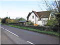
Smithyard Cottage, on the B3190 near Washford
Image: © Roger Cornfoot
Taken: 16 Nov 2010
0.06 miles
2
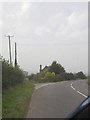
Road Junction
A junction between B3190 and an un-classified road, looking south. The Washford transmitters can be seen in the distance on the right hand side.
Image: © Tim Cook
Taken: 16 Oct 2005
0.06 miles