IMAGES TAKEN NEAR TO
Beggearnhuish, WATCHET, TA23 0LZ
Introduction
This page details the photographs taken nearby to TA23 0LZ by members of the Geograph project.
The Geograph project started in 2005 with the aim of publishing, organising and preserving representative images for every square kilometre of Great Britain, Ireland and the Isle of Man.

There are currently over 7.5m images from over14,400 individuals and you can help contribute to the project by visiting https://www.geograph.org.uk
Image Map (Loading...)


Getting Data...Please wait
Leaflet Map data © OpenStreetMap
Images are licensed for reuse under creativecommons.org/licenses/by-sa/2.0
Notes
- Clicking on the map will re-center to the selected point.
- The higher the marker number, the further away the image location is from the centre of the postcode.
Image Listing (7 Images Found)
Images are licensed for reuse under creativecommons.org/licenses/by-sa/2.0
Image
Details
Distance
2
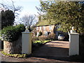
House and gateposts, at Beggearn Huish
Image: © Roger Cornfoot
Taken: 18 Jan 2011
0.05 miles
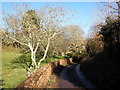
5
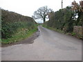
Heading NW at Egypt Cottages, Fair Cross
Image: © Dr Duncan Pepper
Taken: 16 Mar 2011
0.20 miles
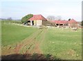
6
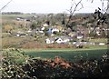
View north towards Torre, from Rocky Lane
Image: © Roger Cornfoot
Taken: 16 Feb 2013
0.22 miles
