IMAGES TAKEN NEAR TO
Goviers Lane, WATCHET, TA23 0EP
Introduction
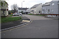
This page details the photographs taken nearby to Goviers Lane, TA23 0EP by members of the Geograph project.
The Geograph project started in 2005 with the aim of publishing, organising and preserving representative images for every square kilometre of Great Britain, Ireland and the Isle of Man.

There are currently over 7.5m images from over14,400 individuals and you can help contribute to the project by visiting https://www.geograph.org.uk
Image Map
Images are licensed for reuse under creativecommons.org/licenses/by-sa/2.0
Notes
- Clicking on the map will re-center to the selected point.
- The higher the marker number, the further away the image location is from the centre of the postcode.
Image Listing (502 Images Found)
Images are licensed for reuse under creativecommons.org/licenses/by-sa/2.0
Image
Details
Distance
1
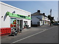
Local shops, in Liddymore Road, Watchet
Image: © Roger Cornfoot
Taken: 25 Apr 2011
0.04 miles
2
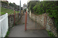
Goviers Lane pedestrian level-crossing swing-gate
At this point, I witnessed a train on its way to Minehead, on which the Beatles were filming some of the railway sequences of the movie 'Hard Day's Night. I can only claim to have actually seen Wilfred Bramble on board, myself.
The steps to the Memorial Ground are on the left.
Image: © Stephen Wilks
Taken: 28 Apr 2010
0.05 miles
3

Watchet : Liddymore Road
A residential road heading through Watchet.
Image: © Lewis Clarke
Taken: 15 Mar 2014
0.06 miles
4

Watchet : South Road
South Road heading through the town of Watchet.
Image: © Lewis Clarke
Taken: 15 Mar 2014
0.07 miles
5
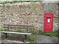
Watchet pound
The old pound is no longer needed for its original purpose. It was also the site of the Court Baron - a local law office - of 1773. However, that doesn't stop it being a useful place today with a bench and a Georgian letterbox.
Image: © Neil Owen
Taken: 10 Sep 2020
0.07 miles
6
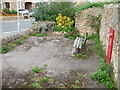
A small pound
What is left of the old Watchet pound is now a small public space. Once it was a pretty isolated place on the hillsidew above the harbour but is now surrounded by modern development.
Image: © Neil Owen
Taken: 10 Sep 2020
0.07 miles
7
School Close, off South Road
Built after the demolition of Watchet County Primary School. Almost opposite a fairly new housing development that replaced the former Watchet Church School.
http://www.geograph.org.uk/photo/1926984
Image: © Stephen Wilks
Taken: 28 Apr 2010
0.08 miles
8

Urban Splash advertisement, East Wharf, Watchet
In 2007 West Somerset Council signed a development agreement with property developer Urban Splash to pave the way for redeveloping the East Wharf at Watchet Harbour. A controversial mixed used development received planning approval in November 2008. The development site is behind the hoarding, although at the time this photo was taken (in the depths of the recession) no work had started. http://www.watchettowncouncil.org/east_wharf.php
Image: © Phil Champion
Taken: 13 Jul 2009
0.08 miles
9
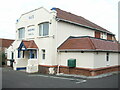
Watchet masonic hall
Built just above the old town pound.
Image: © Neil Owen
Taken: 10 Sep 2020
0.08 miles
10
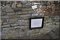
Jubilee Geologic Wall
On the platform of Watchet Railway Station
Image: © Stephen Wilks
Taken: 28 Apr 2010
0.08 miles