IMAGES TAKEN NEAR TO
Maglands Road, WATCHET, TA23 0EB
Introduction
This page details the photographs taken nearby to Maglands Road, TA23 0EB by members of the Geograph project.
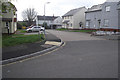
The Geograph project started in 2005 with the aim of publishing, organising and preserving representative images for every square kilometre of Great Britain, Ireland and the Isle of Man.

There are currently over 7.5m images from over14,400 individuals and you can help contribute to the project by visiting https://www.geograph.org.uk
Image Map
Images are licensed for reuse under creativecommons.org/licenses/by-sa/2.0
Notes
- Clicking on the map will re-center to the selected point.
- The higher the marker number, the further away the image location is from the centre of the postcode.
Image Listing (18 Images Found)
Images are licensed for reuse under creativecommons.org/licenses/by-sa/2.0
Image
Details
Distance
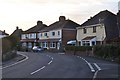
1
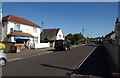
Liddymore Road, Watchet
A fish and chip shop, which has as near neighbours a supermarket and a cafe. Beyond, the road becomes residential.
Image: © Derek Harper
Taken: 24 May 2010
0.08 miles
2
Watchet : Wristland Road
Wristland Road heading into a residential area.
Image: © Lewis Clarke
Taken: 15 Mar 2014
0.16 miles
3
Watchet : Kingsland
A road heading off of Doniford Road in Watchet.
Image: © Lewis Clarke
Taken: 15 Mar 2014
0.17 miles
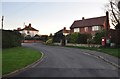
4
Housing estate, at the eastern edge of Watchet
Image: © Roger Cornfoot
Taken: 19 Jul 2012
0.18 miles
5

Watchet : Liddymore Road
A residential road heading through Watchet.
Image: © Lewis Clarke
Taken: 15 Mar 2014
0.18 miles
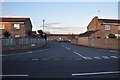
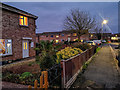
6
School Close, off South Road
Built after the demolition of Watchet County Primary School. Almost opposite a fairly new housing development that replaced the former Watchet Church School.
http://www.geograph.org.uk/photo/1926984
Image: © Stephen Wilks
Taken: 28 Apr 2010
0.18 miles
7
Watchet : Doniford Road
Doniford Road heading through the town of Watchet.
Image: © Lewis Clarke
Taken: 15 Mar 2014
0.18 miles
8
Watchet : Kingsland
A pavement and houses on Kingsland.
Image: © Lewis Clarke
Taken: 31 Dec 2018
0.19 miles
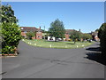
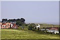
9

Watchet : Memorial Ground
A grassy recreational area in Watchet.
Image: © Lewis Clarke
Taken: 15 Mar 2014
0.21 miles
10
A diesel unit passes between houses and caravans
Image: © Steve Daniels
Taken: 6 Jun 2013
0.22 miles