IMAGES TAKEN NEAR TO
Waddicombe, DULVERTON, TA22 9RY
Introduction
This page details the photographs taken nearby to TA22 9RY by members of the Geograph project.
The Geograph project started in 2005 with the aim of publishing, organising and preserving representative images for every square kilometre of Great Britain, Ireland and the Isle of Man.

There are currently over 7.5m images from over14,400 individuals and you can help contribute to the project by visiting https://www.geograph.org.uk
Image Map
Images are licensed for reuse under creativecommons.org/licenses/by-sa/2.0
Notes
- Clicking on the map will re-center to the selected point.
- The higher the marker number, the further away the image location is from the centre of the postcode.
Image Listing (4 Images Found)
Images are licensed for reuse under creativecommons.org/licenses/by-sa/2.0
Image
Details
Distance
1
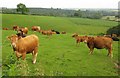
Cattle at West Anstey Farm
By the road west of Rhyll Gate Cross, and puzzled.
Image: © Derek Harper
Taken: 26 Jun 2013
0.13 miles
2
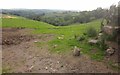
Cattle pasture near West Anstey Farm
Image: © Derek Harper
Taken: 26 Jun 2013
0.18 miles
3
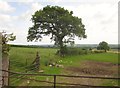
Field boundary near Rhyll Gate Cross
From the road between Badlake Moor Cross and Five Ways Cross.
Image: © Derek Harper
Taken: 26 Jun 2013
0.22 miles
4
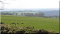
Improved grazing, Exmoor
The southern edge of Exmoor, above West Anstey Farm.
Image: © Richard Webb
Taken: 2 Apr 2012
0.24 miles