IMAGES TAKEN NEAR TO
DULVERTON, TA22 9QH
Introduction
This page details the photographs taken nearby to TA22 9QH by members of the Geograph project.
The Geograph project started in 2005 with the aim of publishing, organising and preserving representative images for every square kilometre of Great Britain, Ireland and the Isle of Man.

There are currently over 7.5m images from over14,400 individuals and you can help contribute to the project by visiting https://www.geograph.org.uk
Image Map
Images are licensed for reuse under creativecommons.org/licenses/by-sa/2.0
Notes
- Clicking on the map will re-center to the selected point.
- The higher the marker number, the further away the image location is from the centre of the postcode.
Image Listing (7 Images Found)
Images are licensed for reuse under creativecommons.org/licenses/by-sa/2.0
Image
Details
Distance
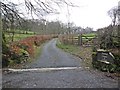
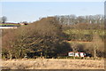
3
On Venford Hill
Looking towards East Anstey Common.
Image: © Roger Cornfoot
Taken: 5 Mar 2014
0.07 miles
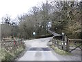
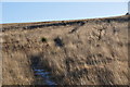
5
North Devon : East Anstey Common
A path heads from Ridge Road down towards Venford across East Anstey Common.
Image: © Lewis Clarke
Taken: 30 Dec 2014
0.18 miles
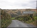
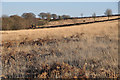
6
North Devon : East Anstey Common
Looking across East Anstey Common on Exmoor.
Image: © Lewis Clarke
Taken: 30 Dec 2014
0.19 miles
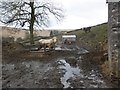
7
North Devon : East Anstey Common
East Anstey Common on Exmoor in North Devon.
Image: © Lewis Clarke
Taken: 30 Dec 2014
0.20 miles