IMAGES TAKEN NEAR TO
Cox Road, WELLINGTON, TA21 9RD
Introduction
This page details the photographs taken nearby to Cox Road, TA21 9RD by members of the Geograph project.
The Geograph project started in 2005 with the aim of publishing, organising and preserving representative images for every square kilometre of Great Britain, Ireland and the Isle of Man.

There are currently over 7.5m images from over14,400 individuals and you can help contribute to the project by visiting https://www.geograph.org.uk
Image Map
Images are licensed for reuse under creativecommons.org/licenses/by-sa/2.0
Notes
- Clicking on the map will re-center to the selected point.
- The higher the marker number, the further away the image location is from the centre of the postcode.
Image Listing (11 Images Found)
Images are licensed for reuse under creativecommons.org/licenses/by-sa/2.0
Image
Details
Distance
1
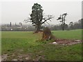
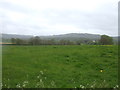
Field boundary on Foxdown Hill
The trees in this landscape suggest that these fields formed parkland around Foxdown House, which is off to the right. Down the hill at Rockwell Green are Image and the church spire in Image
Image: © Derek Harper
Taken: 22 Jan 2010
0.10 miles
2
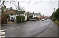
Swains Lane, Wellington
The little C18 thatched cottage on the left is listed http://webapp1.somerset.gov.uk/her/details.asp?prn=46363 . View from the junction with Ardwyn.
Image: © Derek Harper
Taken: 22 Jan 2010
0.16 miles
3
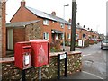
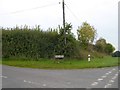
Postbox, Swains Lane, Wellington
An Elizabeth II postbox, number TA21 337, beside a red pouch box, and near the entrance to footpath WG 17/3 on the left.
Image: © Derek Harper
Taken: 22 Jan 2010
0.16 miles
5
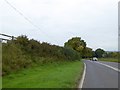
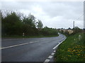
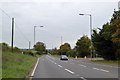
Wide verge by A38 (Oldway Road) west of Stallards
The wide verge is to protect vehicles emerging from the side road; making this road into the Wellington by-pass has meant that it had to be realigned here
Image: © David Smith
Taken: 17 Oct 2015
0.17 miles
6
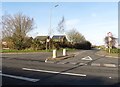
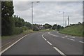
Oldway Road junction with Stallards
Stallards is the name of both the road and its destination. Oldway Road is the A38
Image: © David Smith
Taken: 17 Oct 2015
0.18 miles
9
A38 (Oldway Road) at the junction with Swains Lane
The A38 formerly ran along the main street of Wellington, but has been diverted to run along the "old way" to by-pass the town
Image: © David Smith
Taken: 17 Oct 2015
0.22 miles
10
Wellington : Oldway Road, A38
The A38 heads around the outside of Wellington here.
Image: © Lewis Clarke
Taken: 22 Jun 2013
0.24 miles