IMAGES TAKEN NEAR TO
Middle Green Road, WELLINGTON, TA21 9NS
Introduction
This page details the photographs taken nearby to Middle Green Road, TA21 9NS by members of the Geograph project.
The Geograph project started in 2005 with the aim of publishing, organising and preserving representative images for every square kilometre of Great Britain, Ireland and the Isle of Man.

There are currently over 7.5m images from over14,400 individuals and you can help contribute to the project by visiting https://www.geograph.org.uk
Image Map
Images are licensed for reuse under creativecommons.org/licenses/by-sa/2.0
Notes
- Clicking on the map will re-center to the selected point.
- The higher the marker number, the further away the image location is from the centre of the postcode.
Image Listing (11 Images Found)
Images are licensed for reuse under creativecommons.org/licenses/by-sa/2.0
Image
Details
Distance
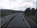
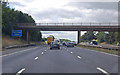
4
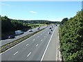
M5 passing Wellington
Looking west (towards Exeter) from the minor road near Legglands
Image: © David Smith
Taken: 30 Aug 2010
0.22 miles
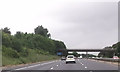
6
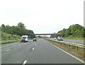
Minor road near Legglands
A view north from the bridge over the M5
Image: © David Smith
Taken: 30 Aug 2010
0.23 miles
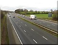
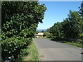
7

Minor road crossing M5 at Legglands
This minor road is used by traffic travelling from Wellington to the Wellington Monument
Image: © David Smith
Taken: 10 Jun 2011
0.23 miles
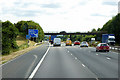
9
M5 Wellington Hill Road bridge
23 miles to next services, just before Exeter.
Image: © Julian P Guffogg
Taken: 9 Aug 2013
0.25 miles