IMAGES TAKEN NEAR TO
Gay Street, WELLINGTON, TA21 9EY
Introduction
This page details the photographs taken nearby to Gay Street, TA21 9EY by members of the Geograph project.
The Geograph project started in 2005 with the aim of publishing, organising and preserving representative images for every square kilometre of Great Britain, Ireland and the Isle of Man.

There are currently over 7.5m images from over14,400 individuals and you can help contribute to the project by visiting https://www.geograph.org.uk
Image Map
Images are licensed for reuse under creativecommons.org/licenses/by-sa/2.0
Notes
- Clicking on the map will re-center to the selected point.
- The higher the marker number, the further away the image location is from the centre of the postcode.
Image Listing (44 Images Found)
Images are licensed for reuse under creativecommons.org/licenses/by-sa/2.0
Image
Details
Distance
1
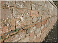
Courses on Priory Gardens
A wall of brick, probably quite old, has a course of what appears to be slate set into it. An early form of damp proofing?
Image: © Neil Owen
Taken: 14 Feb 2023
0.13 miles
2
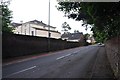
Wellington : Taunton Road
Looking along Taunton Road as it heads into Wellington.
Image: © Lewis Clarke
Taken: 7 Jun 2014
0.14 miles
3
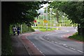
Wellington : Taunton Road B3187
Looking along Taunton Road as it approaches a roundabout.
Image: © Lewis Clarke
Taken: 7 Jun 2014
0.15 miles
4
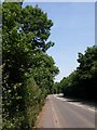
Taunton Road, Wellington
The B3187 to Taunton leaves Wellington along this tree-lined stretch.
Image: © Derek Harper
Taken: 3 Jun 2009
0.17 miles
5
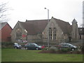
St. John's School
Designed by C.E. Giles and built 1855-6.
Image: © Jonathan Thacker
Taken: 20 Mar 2013
0.18 miles
6
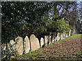
A row of stones
Many older gravestones have been lined up against the boundary wall. The graveyard was in use from Mediaeval times.
Image: © Neil Owen
Taken: 14 Feb 2023
0.19 miles
7
A mole in the graveyard
Naturally the presence of a mole or two in the graveyards does cause some concern, but it's good to know they are abouts.
St John the Baptist church was actually St Mary the Virgin church from its founding in, perhaps, the twelfth century. Somewhere along the line (and it's not recorded anywhere) the dedication was transfered to St John the Baptist. It's possible the name changed after the Reformation.
Image: © Neil Owen
Taken: 14 Feb 2023
0.20 miles
8
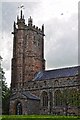
Wellington : St John The Baptist Church
The church underwent two major restorations in 1848/50 and 1938, and in 1986/7 the Victorian pews were removed and the nave and chancel refloored. In the east window of the Lady chapel is the church’s rarest feature, a Lily Crucifix carved on the centre mullion, but perhaps its most famous feature is the impressive monument in the north chancel aisle to Sir John Popham who was Chief Justice of England under Elizabeth I and James I. He was, perhaps, Wellington’s most famous resident and lived in a substantial mansion in the town. The first organ was placed in the church in around 1700 and the present instrument was last rebuilt in 1997 at a cost of £60,000.
Image: © Lewis Clarke
Taken: 7 Jun 2014
0.21 miles
9
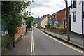
Buckwell
A narrow residential street near the centre of Wellington.
Image: © Bill Boaden
Taken: 10 Jul 2020
0.21 miles
10
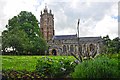
Wellington : St John The Baptist Church
There has probably been a place of worship on the site of the Parish Church of St John the Baptist, Wellington since Saxon times but the present building is mostly in the Perpendicular style of the 15th century.
Image: © Lewis Clarke
Taken: 7 Jun 2014
0.21 miles