IMAGES TAKEN NEAR TO
High Path, WELLINGTON, TA21 8NH
Introduction
This page details the photographs taken nearby to High Path, TA21 8NH by members of the Geograph project.
The Geograph project started in 2005 with the aim of publishing, organising and preserving representative images for every square kilometre of Great Britain, Ireland and the Isle of Man.

There are currently over 7.5m images from over14,400 individuals and you can help contribute to the project by visiting https://www.geograph.org.uk
Image Map
Images are licensed for reuse under creativecommons.org/licenses/by-sa/2.0
Notes
- Clicking on the map will re-center to the selected point.
- The higher the marker number, the further away the image location is from the centre of the postcode.
Image Listing (35 Images Found)
Images are licensed for reuse under creativecommons.org/licenses/by-sa/2.0
Image
Details
Distance
1
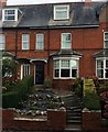
House built 1927 in Station Road, Wellington
A house in Wellington, Somerset made in 1927. It is named Iona and was made for the people that worked in Foxes' factory.
Image: © Dawn Forrest
Taken: 3 Oct 2015
0.03 miles
2
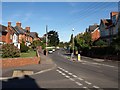
Waterloo Road, Wellington
The shadow in the foreground is cast by Image, so this is a view from the junction with Corams Lane.
Image: © Derek Harper
Taken: 29 Sep 2009
0.08 miles
3
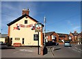
Sportsmans Arms, Wellington
On the B3187 Waterloo Road to the west of the town centre, and virtually opposite Image Beyond, the road bends right at the junction with Corams Lane.
Image: © Derek Harper
Taken: 29 Sep 2009
0.12 miles
4
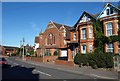
Methodist church, Wellington
The Bible Christian Methodist church on Waterloo Road. The Bible Christian movement began in North Devon in 1815. I could not see a date on the building.
Image: © Derek Harper
Taken: 29 Sep 2009
0.13 miles
5
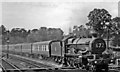
Penzance - Wolverhampton express running down through Wellington (Somerset)
Making what speed it can on a Summer Saturday down the long bank from Whiteball Summit, ex-GW collett 'Castle' 4-6-0 No. 5057 'Earl Waldegrave' (built 6/36 as 'Penrice Castle' and renamed in 8/37 was withdrawn in 3/64) heads the 07.30 Penzance - Wolverhampton Low Level (due 17.35).
Image: © Ben Brooksbank
Taken: 28 Aug 1954
0.13 miles
7
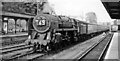
Wellington Station and Down express
View NE, towards Taunton, Bristol, London etc.; ex-Great Western West of England Main line to Exeter, Plymouth and Penzance. The train is the 13.25 Saturday relief express, Paddington to Kingswear, headed by BR Britannia 4-6-2 No. 70016 'Ariel', which was one of the 15 Britannias that were tolerated by the Western Region for a few years. Along with a constant stream of Summer Saturday expresses on the Taunton - Exeter stretch, it is about to tackle the steepest (1:66-90) last three miles of the climb to Whiteball Summit.
Image: © Ben Brooksbank
Taken: 28 Aug 1954
0.13 miles
8
Five quid a game
Three for O.A.P.s and young 'uns. Wellington R.F.C.'s ticket office.
Image: © Neil Owen
Taken: 14 Feb 2023
0.14 miles
9
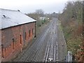
Site of former railway station, Wellington
Viewed from the footbridge, seen in the background of Ben Brooksbank's shot, taken in 1954, when the station was open for business: Image
Image: © Roger Cornfoot
Taken: 18 Jan 2014
0.15 miles
10
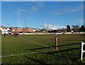
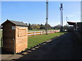
Bridgwater and Albion Rugby Ground
The game in progress finished BARFC 2nds 10, Old Reds 2nds 26
Despite having more possession, the Bridgwater 2nds could not convert this to a win. Some poor handling and decision making saw opportunities squandered whilst virtually every time Old Reds attacked, they scored.
Image: © Roger Cornfoot
Taken: 28 Jan 2017
0.15 miles