IMAGES TAKEN NEAR TO
Beech Grove, WELLINGTON, TA21 8NG
Introduction
This page details the photographs taken nearby to Beech Grove, TA21 8NG by members of the Geograph project.
The Geograph project started in 2005 with the aim of publishing, organising and preserving representative images for every square kilometre of Great Britain, Ireland and the Isle of Man.

There are currently over 7.5m images from over14,400 individuals and you can help contribute to the project by visiting https://www.geograph.org.uk
Image Map
Images are licensed for reuse under creativecommons.org/licenses/by-sa/2.0
Notes
- Clicking on the map will re-center to the selected point.
- The higher the marker number, the further away the image location is from the centre of the postcode.
Image Listing (42 Images Found)
Images are licensed for reuse under creativecommons.org/licenses/by-sa/2.0
Image
Details
Distance
1
A curious bowl
Set in the corner of Wellington Park is this mounted ceramic tile bowl. No sign of what it is, though.
The park was designed in 1902 and was originally Grade II listed. However, the park fell into some decline over time but was happily restored thanks to Heritage Lottery Funding in 2000. This and the subsequent work by Friends and volunteers enabled the park to be upgraded to II* listing in 2013.
Image: © Neil Owen
Taken: 14 Feb 2023
0.04 miles
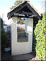
2
Fox's gift
The caretaker's lodge is an unusual design, courtesy of Robert Veitch and Sons and the generous donation of land by Fox Brothers and Company. The idea was to provide a public park to mark the coronation of King Edward VII, and a large plaque illustrates this.
Image: © Neil Owen
Taken: 14 Feb 2023
0.04 miles
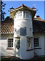
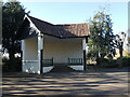
3
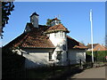
The caretaker's lodge
Built by Follet brothers of Wellington, the lodge was part of the original park designs.
Image: © Neil Owen
Taken: 14 Feb 2023
0.04 miles
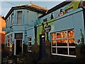
5
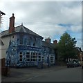
The Dolphin Inn, Wellington
The facade of this building was converted into a huge mural during the summer of 2013.
Image: © David Smith
Taken: 30 Aug 2013
0.06 miles
6
Wellington Park bandstand
The park was laid out to the designs of Robert Veitch and Sons of Exeter, with this roughcast and clay-tiled bandstand near the west corner. The glazed panels of the angled back wall have been filled in; a turret used to stand on top of it but is now lost.
Image: © Neil Owen
Taken: 14 Feb 2023
0.06 miles
7
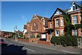
Methodist church, Wellington
The Bible Christian Methodist church on Waterloo Road. The Bible Christian movement began in North Devon in 1815. I could not see a date on the building.
Image: © Derek Harper
Taken: 29 Sep 2009
0.07 miles
8
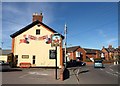
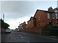
Sportsmans Arms, Wellington
On the B3187 Waterloo Road to the west of the town centre, and virtually opposite Image Beyond, the road bends right at the junction with Corams Lane.
Image: © Derek Harper
Taken: 29 Sep 2009
0.07 miles
10
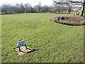
Keep off this grass
Others have found a part of the park that might not be under orders.
Image: © Neil Owen
Taken: 14 Feb 2023
0.08 miles