IMAGES TAKEN NEAR TO
Pyles Thorne, WELLINGTON, TA21 8DY
Introduction
This page details the photographs taken nearby to TA21 8DY by members of the Geograph project.
The Geograph project started in 2005 with the aim of publishing, organising and preserving representative images for every square kilometre of Great Britain, Ireland and the Isle of Man.

There are currently over 7.5m images from over14,400 individuals and you can help contribute to the project by visiting https://www.geograph.org.uk
Image Map
Images are licensed for reuse under creativecommons.org/licenses/by-sa/2.0
Notes
- Clicking on the map will re-center to the selected point.
- The higher the marker number, the further away the image location is from the centre of the postcode.
Image Listing (8 Images Found)
Images are licensed for reuse under creativecommons.org/licenses/by-sa/2.0
Image
Details
Distance
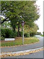
1
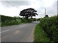
Ford Street near the junction with West Buckland Road (the A38)
Image: © David Gearing
Taken: 30 May 2012
0.11 miles
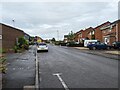
2
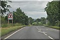
Wellington : West Buckland Road, A38
The A38 heading out past Wellington towards Taunton.
Image: © Lewis Clarke
Taken: 22 Jun 2013
0.11 miles
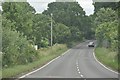
3
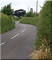
Ford Street
The road into Wellington from the hamlet of Ford Street is also called Ford Street. Here it negotiates a double bend before reaching the A38.
Image: © Derek Harper
Taken: 18 Jun 2009
0.12 miles
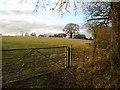
4
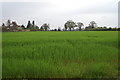
Field of crops looking to A38
Image: © Adrian and Janet Quantock
Taken: 30 Apr 2006
0.15 miles
5
Oldway Road (A38) seen from the end of Hoyles Road, Wellington
The A38 used to run through the main street of Wellington, but now by-passes the town along this "old way"
Image: © David Smith
Taken: 17 Oct 2015
0.16 miles
7
Taunton Deane District : West Buckland Road, A38
Image: © Lewis Clarke
Taken: 22 Jun 2013
0.22 miles
8
Field by Jurston Lane
The field on the opposite side of the lane from Image, also bathed in weak afternoon sunlight.
Image: © Derek Harper
Taken: 18 Jan 2010
0.24 miles