IMAGES TAKEN NEAR TO
Fore Street, WELLINGTON, TA21 8AG
Introduction
This page details the photographs taken nearby to Fore Street, TA21 8AG by members of the Geograph project.
The Geograph project started in 2005 with the aim of publishing, organising and preserving representative images for every square kilometre of Great Britain, Ireland and the Isle of Man.

There are currently over 7.5m images from over14,400 individuals and you can help contribute to the project by visiting https://www.geograph.org.uk
Image Map
Images are licensed for reuse under creativecommons.org/licenses/by-sa/2.0
Notes
- Clicking on the map will re-center to the selected point.
- The higher the marker number, the further away the image location is from the centre of the postcode.
Image Listing (153 Images Found)
Images are licensed for reuse under creativecommons.org/licenses/by-sa/2.0
Image
Details
Distance
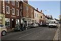
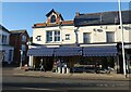
1
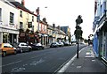
Wellington Fore Street
This was once the old A38 until bypassed by the M5. Looking towards the west not long before sunset as well as a pub and Barclays bank the museum are all on the left.
Image: © roger geach
Taken: 18 Sep 2010
0.00 miles
2
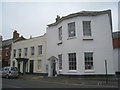
35 and 37 Fore Street
35(on the right) dates from about 1800 http://www.britishlistedbuildings.co.uk/en-428786-taunton-deane-borough-council-offices-we#.VrEfhNCWOTw and 37 is almost a century older http://www.britishlistedbuildings.co.uk/en-269966-37-fore-street-wellington-somerset#.VrEf5NCWOTw
Image: © Jonathan Thacker
Taken: 20 Mar 2013
0.01 miles
3
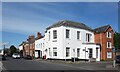
Fore Street, Wellington
Some of the pleasant old buildings along what was once a main road before the town was bypassed.
Image: © Des Blenkinsopp
Taken: 17 May 2024
0.01 miles
4
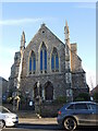
Wellington U.R. Church
The church was originally the Congregational Chapel of about 1860, and is based on the Gothic style of the thirteenth century. Grade II listed.
Image: © Neil Owen
Taken: 14 Feb 2023
0.02 miles
5
Fore Street
Interesting mix of building styles in a thriving town centre.
Image: © Peter Turner
Taken: 8 Sep 2016
0.02 miles
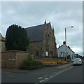
7
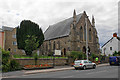
Wellington United Reformed Church
Formerly a Congregational chapel. It is built in Victorian Gothic style and is Grade II listed.
Image: © Bill Boaden
Taken: 10 Jul 2020
0.02 miles
8

Luson Surgery
Former eighteenth century house http://www.britishlistedbuildings.co.uk/en-269967-41-fore-street-wellington-somerset#.VrEcd9CWOTw
Image: © Jonathan Thacker
Taken: 20 Mar 2013
0.02 miles
9
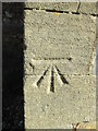
Ordnance Survey Cut Mark
This OS cut mark can be found on the corner of the United Reformed Church. It marks a point 78.020m above mean sea level.
Image: © Adrian Dust
Taken: 9 Feb 2015
0.02 miles
10
HT Perry and Son and Granddaughter, Wellington
Traditional Hardware store.
Image: © Roger Cornfoot
Taken: 12 Jan 2022
0.02 miles