IMAGES TAKEN NEAR TO
Langford Budville, WELLINGTON, TA21 0RS
Introduction
This page details the photographs taken nearby to TA21 0RS by members of the Geograph project.
The Geograph project started in 2005 with the aim of publishing, organising and preserving representative images for every square kilometre of Great Britain, Ireland and the Isle of Man.

There are currently over 7.5m images from over14,400 individuals and you can help contribute to the project by visiting https://www.geograph.org.uk
Image Map
Images are licensed for reuse under creativecommons.org/licenses/by-sa/2.0
Notes
- Clicking on the map will re-center to the selected point.
- The higher the marker number, the further away the image location is from the centre of the postcode.
Image Listing (12 Images Found)
Images are licensed for reuse under creativecommons.org/licenses/by-sa/2.0
Image
Details
Distance
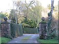
1
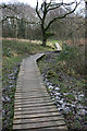
Taunton Deane District : Farm Track
A farm track heading towards Middle Hill Farm.
Image: © Lewis Clarke
Taken: 7 Jun 2014
0.09 miles
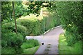
2
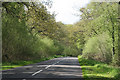
Taunton Deane District : Road
A road heading through the Taunton Deane District.
Image: © Lewis Clarke
Taken: 7 Jun 2014
0.13 miles
3
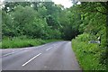
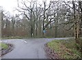
Taunton Deane District : Road
A road at the junction with a signpost pointing in the direction of Poleshill and Bathealton.
Image: © Lewis Clarke
Taken: 7 Jun 2014
0.14 miles
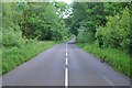
4
Langford Budville: road to Wiveliscombe
Looking north-north-west on Langford Heathfield, with the turning, left, to Poleshill just visible
Image: © Martin Bodman
Taken: 3 May 2006
0.14 miles
6
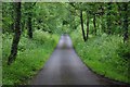
Taunton Deane District : Carrier's Lane
A small lane heading through Langford Heathfield.
Image: © Lewis Clarke
Taken: 7 Jun 2014
0.15 miles
7
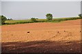
Taunton Deane District : Ploughed Field
Looking across a ploughed field in the Taunton Deane District.
Image: © Lewis Clarke
Taken: 7 Jun 2014
0.17 miles
9
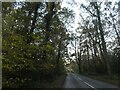
In Langford Heathfield
The road runs through the north-south axis of this woodland
Image: © David Smith
Taken: 3 Nov 2020
0.18 miles