IMAGES TAKEN NEAR TO
Langford Budville, WELLINGTON, TA21 0QX
Introduction
This page details the photographs taken nearby to TA21 0QX by members of the Geograph project.
The Geograph project started in 2005 with the aim of publishing, organising and preserving representative images for every square kilometre of Great Britain, Ireland and the Isle of Man.

There are currently over 7.5m images from over14,400 individuals and you can help contribute to the project by visiting https://www.geograph.org.uk
Image Map
Images are licensed for reuse under creativecommons.org/licenses/by-sa/2.0
Notes
- Clicking on the map will re-center to the selected point.
- The higher the marker number, the further away the image location is from the centre of the postcode.
Image Listing (8 Images Found)
Images are licensed for reuse under creativecommons.org/licenses/by-sa/2.0
Image
Details
Distance
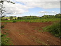
5
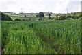
Taunton Deane District : Grassy Field
A grassy field in the Taunton Deane District.
Image: © Lewis Clarke
Taken: 7 Jun 2014
0.23 miles
6
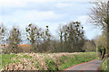
Nynehead: mistletoe-clad trees
By an old entrance to Chipley Park. Looking roughly north east
Image: © Martin Bodman
Taken: 2 Apr 2006
0.25 miles
7
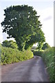
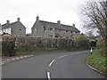
Taunton Deane District : Country Lane
Looking along the country lane in the Taunton Deane District.
Image: © Lewis Clarke
Taken: 7 Jun 2014
0.25 miles
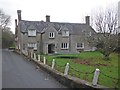
8
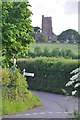
Taunton Deane District : Langford Gate
Looking towards Langford Gate with St Peter's Church on the hillside.
Image: © Lewis Clarke
Taken: 7 Jun 2014
0.25 miles