IMAGES TAKEN NEAR TO
Hockworthy, WELLINGTON, TA21 0NW
Introduction
This page details the photographs taken nearby to TA21 0NW by members of the Geograph project.
The Geograph project started in 2005 with the aim of publishing, organising and preserving representative images for every square kilometre of Great Britain, Ireland and the Isle of Man.

There are currently over 7.5m images from over14,400 individuals and you can help contribute to the project by visiting https://www.geograph.org.uk
Image Map
Images are licensed for reuse under creativecommons.org/licenses/by-sa/2.0
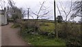
Notes
- Clicking on the map will re-center to the selected point.
- The higher the marker number, the further away the image location is from the centre of the postcode.
Image Listing (34 Images Found)
Images are licensed for reuse under creativecommons.org/licenses/by-sa/2.0
Image
Details
Distance
1
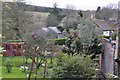
Hockworthy : Hockworthy Gardens & Scenery
Looking down towards the gardens and houses of Hockworthy.
Image: © Lewis Clarke
Taken: 15 Jan 2013
0.01 miles
2
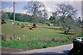
Rural Springtime scene at Hockworthy, 1963
View eastward, Parish Church of St Simon ahead.
Image: © Ben Brooksbank
Taken: 22 Apr 1963
0.02 miles
4
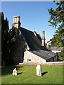
Village hall, Hockworthy
A view from the churchyard of the church of St Simon and St Jude. This was formerly the village school, built in 1860 http://www.hockworthy.org.uk/hallhire.htm http://www.britishlistedbuildings.co.uk/en-95931-the-old-school-hockworthy .
Image: © Derek Harper
Taken: 14 Jul 2011
0.03 miles
5
Hockworthy : Village Hall
The village hall in Hockworthy beside the church.
Image: © Lewis Clarke
Taken: 15 Jan 2013
0.03 miles
6
Early morning walk, Hockworthy
A view from the churchyard of Image The house is Hurfords Mead, with C16 features http://www.britishlistedbuildings.co.uk/en-95930-hurfords-mead-hockworthy , although it was much altered in the 1960s.
Image: © Derek Harper
Taken: 14 Jul 2011
0.04 miles
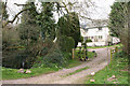
7
Hockworthy : Hurfords Mead
Hurfords Mead 5.4.66 GV II House. C16 and C17, extensively renovated and partly rebuilt circa 1965. Plastered stone rubble; stone rubble stacks one with stone rubble chimneyshaft, the other topped with C20 brick; slate roof, formerly thatch.
Image: © Lewis Clarke
Taken: 15 Jan 2013
0.04 miles
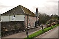
8
Hockworthy: entrance to Hurds Farm
Looking north-north-east. The Ordnance Survey 1:25000 map indicates a public bridleway running past the farmhouse to Ashbrittle
Image: © Martin Bodman
Taken: 7 Apr 2006
0.04 miles
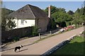
9
Bridleway at Hurd Farm, Hockworthy
The bridleway is one of two that run north-east from the village to Lee; the alternative is a road via Staple Cross. This bridleway climbs over the hill, the other starts close to the church and follows a contour around the hill on the east side
Image: © David Smith
Taken: 23 Mar 2015
0.04 miles
10
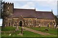
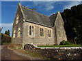
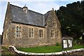
Hockworthy : Church of St Simon and St Jude
HOCKWORTHY ST 01 NW 4/78 Church of St Simon and St Jude - 5.4.66 GV II* Small parish church. Norman font. The tower is probably C15 but was heavily restored 1848, the rest was rebuilt in 1865 by the young architect Charles Durnford Greenway. Local chert stone rubble to the tower, the rest of the same stone but snecked; limestone detail; slate roof.
Image: © Lewis Clarke
Taken: 15 Jan 2013
0.05 miles