IMAGES TAKEN NEAR TO
Greenham, WELLINGTON, TA21 0LZ
Introduction
This page details the photographs taken nearby to TA21 0LZ by members of the Geograph project.
The Geograph project started in 2005 with the aim of publishing, organising and preserving representative images for every square kilometre of Great Britain, Ireland and the Isle of Man.

There are currently over 7.5m images from over14,400 individuals and you can help contribute to the project by visiting https://www.geograph.org.uk
Image Map
Images are licensed for reuse under creativecommons.org/licenses/by-sa/2.0
Notes
- Clicking on the map will re-center to the selected point.
- The higher the marker number, the further away the image location is from the centre of the postcode.
Image Listing (17 Images Found)
Images are licensed for reuse under creativecommons.org/licenses/by-sa/2.0
Image
Details
Distance
1
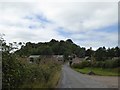
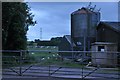
Wiseburrow and Gamlins Farms
The wood beyond, Wiseburrow Covert, hides a quarry
Image: © David Smith
Taken: 31 Aug 2016
0.04 miles

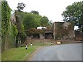
3
Wiseburrow Farm
Wiseburrow Covert is behind the farm, and Wiseburrow Copse to the west
Image: © David Smith
Taken: 11 Dec 2020
0.06 miles
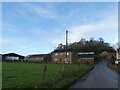
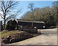
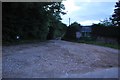
4
Taunton Deane District : Barn
Looking up the grazel driveway towards a barn.
Image: © Lewis Clarke
Taken: 7 Jun 2014
0.06 miles
5
Wiseburrow Farm
Image: © Derek Harper
Taken: 3 Mar 2010
0.06 miles
6
Taunton Deane District : Gamlins Farm
Looking towards Gamlins Farm in the Taunton Deane District.
Image: © Lewis Clarke
Taken: 7 Jun 2014
0.06 miles
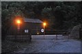
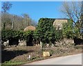
7
Lime kilns at Wiseburrow
The vegetation has been cleared since Roger Cornfoot took this picture seven months ago Image
Image: © David Smith
Taken: 31 Aug 2016
0.07 miles
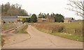
10
Taunton Deane District : Farm Track
A farm track near Wisebarrow Covert.
Image: © Lewis Clarke
Taken: 7 Jun 2014
0.07 miles