IMAGES TAKEN NEAR TO
Greenham, WELLINGTON, TA21 0JW
Introduction
This page details the photographs taken nearby to TA21 0JW by members of the Geograph project.
The Geograph project started in 2005 with the aim of publishing, organising and preserving representative images for every square kilometre of Great Britain, Ireland and the Isle of Man.

There are currently over 7.5m images from over14,400 individuals and you can help contribute to the project by visiting https://www.geograph.org.uk
Image Map
Images are licensed for reuse under creativecommons.org/licenses/by-sa/2.0
Notes
- Clicking on the map will re-center to the selected point.
- The higher the marker number, the further away the image location is from the centre of the postcode.
Image Listing (5 Images Found)
Images are licensed for reuse under creativecommons.org/licenses/by-sa/2.0
Image
Details
Distance
1
Higher Greenham from Fisher's Hill
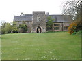
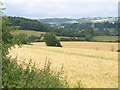
Taken from the same spot as Image, looking to the left, across the Tone valley. Higher Greenham is a hamlet of farms and cottages - only part of Woodham's Farm (left) can be glimpsed. Across the valley, right of centre and set against trees, is the C19 Image http://webapp1.somerset.gov.uk/her/details.asp?prn=40028 .
Image: © Derek Harper
Taken: 24 Jun 2010
0.05 miles
2
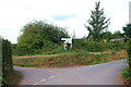
Higher Greenham
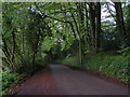
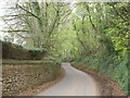
Road junction on Fisher's Hill.
Image: © Wayland Smith
Taken: 21 Sep 2021
0.16 miles