IMAGES TAKEN NEAR TO
Stawley, WELLINGTON, TA21 0HS
Introduction
This page details the photographs taken nearby to TA21 0HS by members of the Geograph project.
The Geograph project started in 2005 with the aim of publishing, organising and preserving representative images for every square kilometre of Great Britain, Ireland and the Isle of Man.

There are currently over 7.5m images from over14,400 individuals and you can help contribute to the project by visiting https://www.geograph.org.uk
Image Map
Images are licensed for reuse under creativecommons.org/licenses/by-sa/2.0
Notes
- Clicking on the map will re-center to the selected point.
- The higher the marker number, the further away the image location is from the centre of the postcode.
Image Listing (4 Images Found)
Images are licensed for reuse under creativecommons.org/licenses/by-sa/2.0
Image
Details
Distance
1
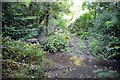
Ford at Stawley
This ford is found on the West Deane Way at Stawley.
Image: © John Walton
Taken: 18 Sep 2016
0.12 miles
2
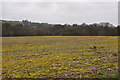
Taunton Deane District : Grassy Field
Looking out across a field in the Taunton Deane countryside.
Image: © Lewis Clarke
Taken: 6 Apr 2014
0.21 miles
3
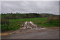
Taunton Deane District : Country Lane & Field
Looking out towards a grassy field from the lane.
Image: © Lewis Clarke
Taken: 6 Apr 2014
0.23 miles
4
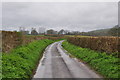
Taunton Deane District : Country Lane
A small country lane heading through the Taunton Deane countryside.
Image: © Lewis Clarke
Taken: 6 Apr 2014
0.24 miles