IMAGES TAKEN NEAR TO
WELLINGTON, TA21 0HE
Introduction
This page details the photographs taken nearby to TA21 0HE by members of the Geograph project.
The Geograph project started in 2005 with the aim of publishing, organising and preserving representative images for every square kilometre of Great Britain, Ireland and the Isle of Man.

There are currently over 7.5m images from over14,400 individuals and you can help contribute to the project by visiting https://www.geograph.org.uk
Image Map
Images are licensed for reuse under creativecommons.org/licenses/by-sa/2.0
Notes
- Clicking on the map will re-center to the selected point.
- The higher the marker number, the further away the image location is from the centre of the postcode.
Image Listing (23 Images Found)
Images are licensed for reuse under creativecommons.org/licenses/by-sa/2.0
Image
Details
Distance
1
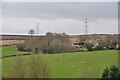
Taunton Deane District : Grassy Countryside
The countryside scenery in Taunton Deane.
Image: © Lewis Clarke
Taken: 9 Feb 2013
0.08 miles
2
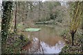
Taunton Deane District : Small Pond
A small pond surrounded by woodland in the Taunton Deane District.
Image: © Lewis Clarke
Taken: 9 Feb 2013
0.08 miles
3
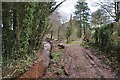
Taunton Deane District : Muddy Path
A muddy path heading through the woodland and countryside.
Image: © Lewis Clarke
Taken: 9 Feb 2013
0.09 miles
4
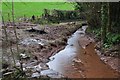
Taunton Deane District : Small Stream & Path
A muddy path alongside a small stream heading through Taunton Deane.
Image: © Lewis Clarke
Taken: 9 Feb 2013
0.10 miles
5
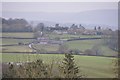
Taunton Deane District : Countryside Scenery
A view across the countryside towards Thorne St Margaret.
Image: © Lewis Clarke
Taken: 9 Feb 2013
0.10 miles
6
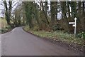
Taunton Deane District : Country Road
A road heading up the hill towards the A38 in Taunton Deane.
Image: © Lewis Clarke
Taken: 9 Feb 2013
0.14 miles
7
Taunton Deane District : Grassy Field
Off the beaten track heading through the countryside along the public footpath.
Image: © Lewis Clarke
Taken: 9 Feb 2013
0.15 miles
8
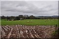
Taunton Deane District : Muddy Field & Sheep
Looking across the muddy field and sheep grazing.
Image: © Lewis Clarke
Taken: 9 Feb 2013
0.16 miles
9
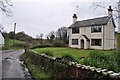
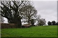
Chitterwell : Road & House
A house alongside the road in Chitterwell.
Image: © Lewis Clarke
Taken: 9 Feb 2013
0.16 miles
10
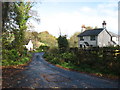
Houses at Chitterwell
The lane leads to Holywell Lake.
Image: © David Purchase
Taken: 5 Nov 2017
0.17 miles