IMAGES TAKEN NEAR TO
East Nynehead, WELLINGTON, TA21 0DD
Introduction
This page details the photographs taken nearby to TA21 0DD by members of the Geograph project.
The Geograph project started in 2005 with the aim of publishing, organising and preserving representative images for every square kilometre of Great Britain, Ireland and the Isle of Man.

There are currently over 7.5m images from over14,400 individuals and you can help contribute to the project by visiting https://www.geograph.org.uk
Image Map
Images are licensed for reuse under creativecommons.org/licenses/by-sa/2.0
Notes
- Clicking on the map will re-center to the selected point.
- The higher the marker number, the further away the image location is from the centre of the postcode.
Image Listing (33 Images Found)
Images are licensed for reuse under creativecommons.org/licenses/by-sa/2.0
Image
Details
Distance
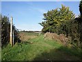
3
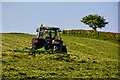
East Nynehead : Grassy Field
A grassy field and tractor.
Image: © Lewis Clarke
Taken: 15 May 2018
0.04 miles
4
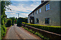
East Nynehead : Country Lane
A country lane heading through the village.
Image: © Lewis Clarke
Taken: 15 May 2018
0.04 miles
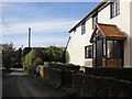
5
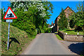
East Nynehead : Country Lane
A road heading through East Nynehead.
Image: © Lewis Clarke
Taken: 15 May 2018
0.05 miles
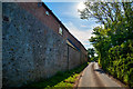
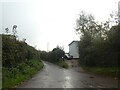
6
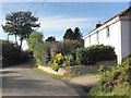
East Nynehead : Country Lane
A country lane heading through East Nynehead.
Image: © Lewis Clarke
Taken: 15 May 2018
0.07 miles
8
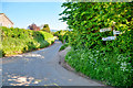
East Nynehead : Country Lane
A small lane heading through East Nynehead.
Image: © Lewis Clarke
Taken: 15 May 2018
0.09 miles
9
Road to Wellington from junction in East Nynehead
Image: © David Smith
Taken: 3 Nov 2020
0.09 miles
10
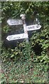
Old Direction Sign - Signpost in East Nynehead
Pyramid finial - 3 arms; Somerset SCC pyramid by the UC road, in parish of Nynehead (Taunton Deane District), T-junction in East Nynehead, on verge, almost in hedge.
Surveyed
Milestone Society National ID: SO_ST1522
Image: © Milestone Society
Taken: Unknown
0.09 miles