IMAGES TAKEN NEAR TO
Nynehead, WELLINGTON, TA21 0BP
Introduction
This page details the photographs taken nearby to TA21 0BP by members of the Geograph project.
The Geograph project started in 2005 with the aim of publishing, organising and preserving representative images for every square kilometre of Great Britain, Ireland and the Isle of Man.

There are currently over 7.5m images from over14,400 individuals and you can help contribute to the project by visiting https://www.geograph.org.uk
Image Map
Images are licensed for reuse under creativecommons.org/licenses/by-sa/2.0
Notes
- Clicking on the map will re-center to the selected point.
- The higher the marker number, the further away the image location is from the centre of the postcode.
Image Listing (20 Images Found)
Images are licensed for reuse under creativecommons.org/licenses/by-sa/2.0
Image
Details
Distance
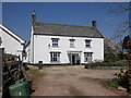
1
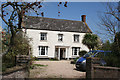
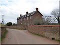
Nynehead: Heywood
Farmhouse for Heywood farm, which is marked Haywood on the 1988 edition of the Ordnance Survey 1:25,000. Looking north-north-east
Image: © Martin Bodman
Taken: 26 Apr 2006
0.00 miles
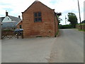
3

Buildings at Heywood
Outbuildings next to Image On the right, with a ball finial, is an C18 loft over store http://www.imagesofengland.org.uk/details/default.aspx?id=271012 , "a good example of an C18 brick agricultural building". The lane is from Nynehead to Langford Budville and is followed by NCN cycle route 3.
Image: © Derek Harper
Taken: 6 Jul 2009
0.02 miles
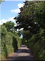
4
Taunton Deane District : Country Lane
A small lane heading through the countryside and towards Heywood Farm.
Image: © Lewis Clarke
Taken: 7 Jun 2014
0.02 miles
6
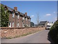
Houses in Heywood, near Nynehead
A terrace of houses, with stone wall in front
Image: © David Smith
Taken: 7 Mar 2016
0.03 miles
7
Terraced cottages, Heywood
A refuse collection vehicle is temporarily blocking the road.
Image: © Roger Cornfoot
Taken: 2 May 2013
0.04 miles
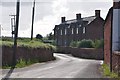
8
Lane to Nynehead
The lane from Langford Budville passes Image, just off to the left, and descends towards Nynehead. It is followed by NCN cycle route 3.
Image: © Derek Harper
Taken: 6 Jul 2009
0.05 miles
9
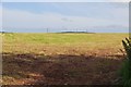
Taunton Deane District : Grassy Field
A grassy field in the Taunton Deane District.
Image: © Lewis Clarke
Taken: 7 Jun 2014
0.08 miles
10
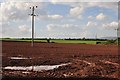
Taunton Deane District : Ploughed Field
Looking across a ploughed field in the Taunton Deane Countryside.
Image: © Lewis Clarke
Taken: 7 Jun 2014
0.08 miles