IMAGES TAKEN NEAR TO
Richards Close, WELLINGTON, TA21 0BD
Introduction
This page details the photographs taken nearby to Richards Close, TA21 0BD by members of the Geograph project.
The Geograph project started in 2005 with the aim of publishing, organising and preserving representative images for every square kilometre of Great Britain, Ireland and the Isle of Man.

There are currently over 7.5m images from over14,400 individuals and you can help contribute to the project by visiting https://www.geograph.org.uk
Image Map
Images are licensed for reuse under creativecommons.org/licenses/by-sa/2.0
Notes
- Clicking on the map will re-center to the selected point.
- The higher the marker number, the further away the image location is from the centre of the postcode.
Image Listing (52 Images Found)
Images are licensed for reuse under creativecommons.org/licenses/by-sa/2.0
Image
Details
Distance
2
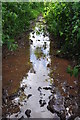
Wellington : Muddy Path
A muddy wet path in the Wellington outskirts.
Image: © Lewis Clarke
Taken: 7 Jun 2014
0.08 miles
3

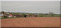
Wellington : Grassy Field
A grassy field on the Wellington outskirts.
Image: © Lewis Clarke
Taken: 7 Jun 2014
0.08 miles
4
Wellington : Footpath
A footpath heading around the outskirts of Wellington.
Image: © Lewis Clarke
Taken: 7 Jun 2014
0.08 miles
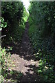
7
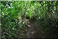
Wellington : Footpath
A footpath heading between trees and towards the town itself.
Image: © Lewis Clarke
Taken: 7 Jun 2014
0.13 miles
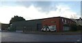
8
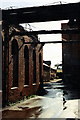
Tonedale Mill deserted
The old woollen mill at Tonedale is now being redeveloped.
Image: © Sarah Smith
Taken: Unknown
0.14 miles
9
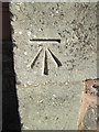
Ordnance Survey Cut Mark
This OS cut mark can be found on the old school building. It marks a point 59.640m above mean sea level.
Image: © Adrian Dust
Taken: 9 Feb 2015
0.14 miles
10
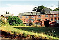
Tonedale Mill
Factory building on the edge of the works. Tonedale House is visible over the clump of greenery on the left. The factory site is now being redeveloped.
Image: © Sarah Smith
Taken: Unknown
0.15 miles