IMAGES TAKEN NEAR TO
CHARD, TA20 9BT
Introduction
This page details the photographs taken nearby to TA20 9BT by members of the Geograph project.
The Geograph project started in 2005 with the aim of publishing, organising and preserving representative images for every square kilometre of Great Britain, Ireland and the Isle of Man.

There are currently over 7.5m images from over14,400 individuals and you can help contribute to the project by visiting https://www.geograph.org.uk
Image Map
Images are licensed for reuse under creativecommons.org/licenses/by-sa/2.0
Notes
- Clicking on the map will re-center to the selected point.
- The higher the marker number, the further away the image location is from the centre of the postcode.
Image Listing (96 Images Found)
Images are licensed for reuse under creativecommons.org/licenses/by-sa/2.0
Image
Details
Distance
1
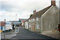
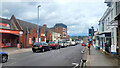
Bath Street, Chard in 1990
Bath Street, Chard in 1990. Some of the older surviving buildings were shops/bakers in Victorian period.
Image: © Clint Mann
Taken: Unknown
0.02 miles
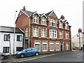
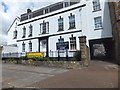
3
Wetherspoon's free house, Chard
Former cinema, now used as a bar and restaurant
Image: © David Smith
Taken: 5 Jun 2014
0.04 miles
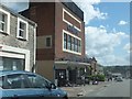
4
Former cinema in Chard High Street
Now a Wetherspoon's pub.
Image: © Rod Allday
Taken: 20 Feb 2012
0.04 miles
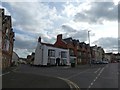
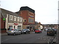
5
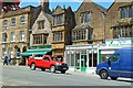
Main Street, Chard
There are many fine historic buildings along this street, mostly listed.
Image: © mike smith
Taken: 6 Aug 2013
0.04 miles
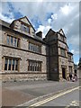
6
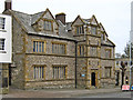
The Grammar School, Chard
Dating from 1583
Image: © Ken Grainger
Taken: 20 Feb 2009
0.04 miles