IMAGES TAKEN NEAR TO
Horseshoe Road, CHARD, TA20 4PS
Introduction
This page details the photographs taken nearby to Horseshoe Road, TA20 4PS by members of the Geograph project.
The Geograph project started in 2005 with the aim of publishing, organising and preserving representative images for every square kilometre of Great Britain, Ireland and the Isle of Man.

There are currently over 7.5m images from over14,400 individuals and you can help contribute to the project by visiting https://www.geograph.org.uk
Image Map
Images are licensed for reuse under creativecommons.org/licenses/by-sa/2.0
Notes
- Clicking on the map will re-center to the selected point.
- The higher the marker number, the further away the image location is from the centre of the postcode.
Image Listing (11 Images Found)
Images are licensed for reuse under creativecommons.org/licenses/by-sa/2.0
Image
Details
Distance
1
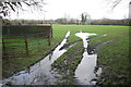
Waterlogged Field at Thorncombe
The entrance to this field on Horseshoe road was full of the rain of recent weeks.
Image: © Nigel Mykura
Taken: 31 Dec 2015
0.07 miles
2
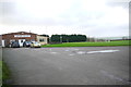
Thorncombe Sports and Social Club
As well as hosting outside sports teams such as football and cricket, the club has indoor activities as well.
Image: © Nigel Mykura
Taken: 31 Dec 2015
0.09 miles
4
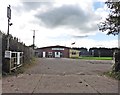
Thorncombe Thorn
View along Horseshoe Road with High Street of Thorncombe going off on the right.
Image: © Nigel Mykura
Taken: 5 Apr 2015
0.18 miles
5
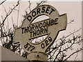
Thorncombe: detail of Thorncombe Thorn finger-post
A close-up of the finial of the finger-post (see Image), giving location and grid reference details.
Image: © Chris Downer
Taken: 3 Apr 2010
0.19 miles
6

Thorncombe: Thorncombe Thorn finger-post
This finger-post has modern fingers but retains the distinctive, original Dorset finial giving location (Thorncombe Thorn) and grid reference.
For a close-up of the finial, see Image
Image: © Chris Downer
Taken: 2 Jul 2009
0.19 miles
7
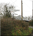
Direction Sign - Signpost by Thorncombe Thorn crossroads
Annulus and bar finial - 4 arms; Dorset halo with NGR by the UC road, in parish of Thorncombe (West Dorset District), opposite Tollhouse, High Street, on grass at junction.
Surveyed
Milestone Society National ID: DO_ST3702
Image: © Alan Rosevear
Taken: 21 Jan 2010
0.19 miles
8
Old Toll House by High Street, Thorncombe parish
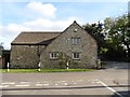
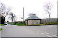
Thorncombe Thorne by the UC road, in parish of Thorncombe (West Dorset District), Turnpike Cottage, High Street, junction with Horseshoe Lane, TA20 4PH.
Grade II listed.
List Entry Number: 1118920 https://historicengland.org.uk/listing/the-list/list-entry/1118920
To be surveyed
Milestone Society National ID: DO.THO
Image: © Milestone Society
Taken: Unknown
0.20 miles
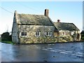
9
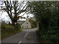
Turnpike Cottage at Thorncombe Thorn
Taken from Horseshoe Lane
Image: © RNE
Taken: 13 Nov 2005
0.20 miles