IMAGES TAKEN NEAR TO
Thorncombe, CHARD, TA20 4PN
Introduction
This page details the photographs taken nearby to TA20 4PN by members of the Geograph project.
The Geograph project started in 2005 with the aim of publishing, organising and preserving representative images for every square kilometre of Great Britain, Ireland and the Isle of Man.

There are currently over 7.5m images from over14,400 individuals and you can help contribute to the project by visiting https://www.geograph.org.uk
Image Map
Images are licensed for reuse under creativecommons.org/licenses/by-sa/2.0
Notes
- Clicking on the map will re-center to the selected point.
- The higher the marker number, the further away the image location is from the centre of the postcode.
Image Listing (8 Images Found)
Images are licensed for reuse under creativecommons.org/licenses/by-sa/2.0
Image
Details
Distance
1
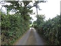
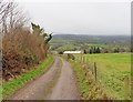
The Orange Way in Dorset and Somerset (2)
The Way turns right onto the bridleway to Elmore Farm.
Image: © Shazz
Taken: 1 Jul 2012
0.02 miles
2
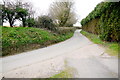
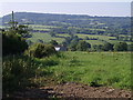
Easthay Lane
Easthay lane runs from Schoolhouse at Holmbush near Thorncombe south west to the Blackwater River and over towards Hawkchurch. This is looking north towards Thorncombe.
Image: © Nigel Mykura
Taken: 5 Apr 2015
0.03 miles
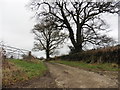
4
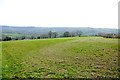
Field at Easthay lane
The lane can be seen running down the right hand side of the image. In the left distance are the roofs of Yonder farm. The field like many on the steep Dorset upland slopes is only for pasture.
Image: © Nigel Mykura
Taken: 5 Apr 2015
0.14 miles
6
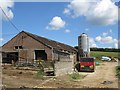
Easthay
Looking down towards the Blackwater valley from Easthay Lane. A couple of roofs of buildings at the farm of Easthay are visible across a field. The hill in the distance is Lambert's Castle Hill.
Image: © Derek Harper
Taken: 5 Jun 2007
0.19 miles