IMAGES TAKEN NEAR TO
High Street, CHARD, TA20 4PE
Introduction
This page details the photographs taken nearby to High Street, TA20 4PE by members of the Geograph project.
The Geograph project started in 2005 with the aim of publishing, organising and preserving representative images for every square kilometre of Great Britain, Ireland and the Isle of Man.

There are currently over 7.5m images from over14,400 individuals and you can help contribute to the project by visiting https://www.geograph.org.uk
Image Map
Images are licensed for reuse under creativecommons.org/licenses/by-sa/2.0
Notes
- Clicking on the map will re-center to the selected point.
- The higher the marker number, the further away the image location is from the centre of the postcode.
Image Listing (101 Images Found)
Images are licensed for reuse under creativecommons.org/licenses/by-sa/2.0
Image
Details
Distance
2
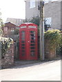
Thorncombe: red telephone box
The phone box stands by the main road junction in the village.
Image: © Chris Downer
Taken: 10 Mar 2015
0.02 miles
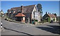
3
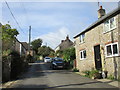
Junction, Thorncombe
Chard Street, right, meets Fore Street. See also Image
Image: © Derek Harper
Taken: 22 Apr 2015
0.02 miles
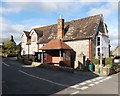
5
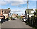
Junction, Thorncombe
The junction is shown in Image and, from the other direction, in Image The adjoining houses down Fore Street on the right are Newhaven http://www.historicengland.org.uk/listing/the-list/list-entry/1324108 and Royal Oak http://www.historicengland.org.uk/listing/the-list/list-entry/1153272 .
Image: © Derek Harper
Taken: 22 Apr 2015
0.03 miles
8

Thorncombe: finger-post and phone
The finger-post has modern replacement fingers (the originals would likely have been rounded rather than pointed), but retains the distinctive finial, with location and grid reference details.
For a close-up of the finial, see Image
Image: © Chris Downer
Taken: 2 Jul 2009
0.03 miles
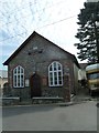
10
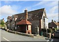
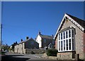
The centre of the village
Bus shelter, village pump and former school (?).
Image: © Jonathan Thacker
Taken: 12 Sep 2017
0.04 miles