IMAGES TAKEN NEAR TO
Ammerham, CHARD, TA20 4LA
Introduction
This page details the photographs taken nearby to Ammerham, TA20 4LA by members of the Geograph project.
The Geograph project started in 2005 with the aim of publishing, organising and preserving representative images for every square kilometre of Great Britain, Ireland and the Isle of Man.

There are currently over 7.5m images from over14,400 individuals and you can help contribute to the project by visiting https://www.geograph.org.uk
Image Map
Images are licensed for reuse under creativecommons.org/licenses/by-sa/2.0
Notes
- Clicking on the map will re-center to the selected point.
- The higher the marker number, the further away the image location is from the centre of the postcode.
Image Listing (3 Images Found)
Images are licensed for reuse under creativecommons.org/licenses/by-sa/2.0
Image
Details
Distance
3
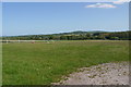
Fields at Ammerham
Ammerham is a small hamlet on the northern bank of the River Axe just upstream from Forde Abbey and just downstream from Winsham, This is looking down towards the river hidden in the trees in the middle of the image.
Image: © Nigel Mykura
Taken: 16 May 2015
0.25 miles