IMAGES TAKEN NEAR TO
Winsham, CHARD, TA20 4BF
Introduction
This page details the photographs taken nearby to TA20 4BF by members of the Geograph project.
The Geograph project started in 2005 with the aim of publishing, organising and preserving representative images for every square kilometre of Great Britain, Ireland and the Isle of Man.

There are currently over 7.5m images from over14,400 individuals and you can help contribute to the project by visiting https://www.geograph.org.uk
Image Map
Images are licensed for reuse under creativecommons.org/licenses/by-sa/2.0
Notes
- Clicking on the map will re-center to the selected point.
- The higher the marker number, the further away the image location is from the centre of the postcode.
Image Listing (5 Images Found)
Images are licensed for reuse under creativecommons.org/licenses/by-sa/2.0
Image
Details
Distance
1
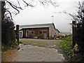
Gateway, Mello View
A modern 'eco' house above Winsham.
Image: © Roger Cornfoot
Taken: 24 Jan 2018
0.00 miles
2
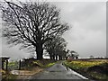
Lane running north east from Winsham
Image: © Roger Cornfoot
Taken: 24 Jan 2018
0.11 miles
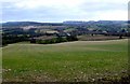
3
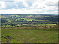
View towards Broadenham Farm
Looking across the Somerset/Dorset border.
Image: © Jonathan Thacker
Taken: 15 Sep 2017
0.13 miles
4
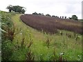
Field above Winsham
This looks like a crop of field beans beside the lane (left) that climbs steeply northeast from Winsham up a chalk ridge.
Image: © Derek Harper
Taken: 28 Jul 2007
0.18 miles
5
Freshly planted field near Winsham
This field is in the very south west corner of the square. The houses lower down the valley are in the next square at Broadenham Farm.
Image: © Nigel Mykura
Taken: 26 Mar 2009
0.23 miles