IMAGES TAKEN NEAR TO
Chaffcombe, CHARD, TA20 4BD
Introduction
This page details the photographs taken nearby to TA20 4BD by members of the Geograph project.
The Geograph project started in 2005 with the aim of publishing, organising and preserving representative images for every square kilometre of Great Britain, Ireland and the Isle of Man.

There are currently over 7.5m images from over14,400 individuals and you can help contribute to the project by visiting https://www.geograph.org.uk
Image Map
Images are licensed for reuse under creativecommons.org/licenses/by-sa/2.0
Notes
- Clicking on the map will re-center to the selected point.
- The higher the marker number, the further away the image location is from the centre of the postcode.
Image Listing (4 Images Found)
Images are licensed for reuse under creativecommons.org/licenses/by-sa/2.0
Image
Details
Distance
3
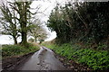
Cricket Lane
This small lane runs from Chard Reservoir at Grantchester Meadows up past Chaffcombe gate Farm and along the north side of Sprays Hill to Cricket Malherbie.
Image: © Nigel Mykura
Taken: 6 Mar 2020
0.21 miles
4
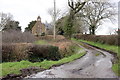
Road to Former Church
The church of Knowle St Giles was converted to a residence in approx 1986. Much of its fabric is Grade II listed but the interior has been pretty much stripped out. There is another separate residence behind the church.
Image: © Nigel Mykura
Taken: 6 Mar 2020
0.23 miles