IMAGES TAKEN NEAR TO
Buckland St. Mary, CHARD, TA20 3LB
Introduction
This page details the photographs taken nearby to TA20 3LB by members of the Geograph project.
The Geograph project started in 2005 with the aim of publishing, organising and preserving representative images for every square kilometre of Great Britain, Ireland and the Isle of Man.

There are currently over 7.5m images from over14,400 individuals and you can help contribute to the project by visiting https://www.geograph.org.uk
Image Map
Images are licensed for reuse under creativecommons.org/licenses/by-sa/2.0
Notes
- Clicking on the map will re-center to the selected point.
- The higher the marker number, the further away the image location is from the centre of the postcode.
Image Listing (9 Images Found)
Images are licensed for reuse under creativecommons.org/licenses/by-sa/2.0
Image
Details
Distance
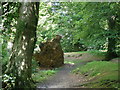
4
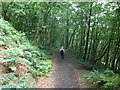
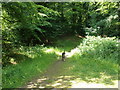
Woodland path, through Castle Neroche
Image: © Roger Cornfoot
Taken: 27 Jun 2009
0.10 miles
5
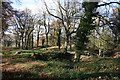
Staple Fitzpaine: Castle Neroche
Looking west-north-west on Forestry Commission land. A motte-and-bailey castle was constructed here in 1068, a time of turmoil in the west country. It was abandoned early in the 12th century but the ramparts still stand. Neroche was a part of a royal forest in medieval times
Image: © Martin Bodman
Taken: 18 Nov 2006
0.13 miles
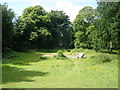
6
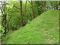
Bank at Castle Neroche
Part of the eastern earthworks of Castle Neroche, perched on a wooded summit in the Blackdown Hills.
Image: © Derek Harper
Taken: 13 May 2006
0.15 miles