IMAGES TAKEN NEAR TO
Dominy Close, CHARD, TA20 2LB
Introduction
This page details the photographs taken nearby to Dominy Close, TA20 2LB by members of the Geograph project.
The Geograph project started in 2005 with the aim of publishing, organising and preserving representative images for every square kilometre of Great Britain, Ireland and the Isle of Man.

There are currently over 7.5m images from over14,400 individuals and you can help contribute to the project by visiting https://www.geograph.org.uk
Image Map
Images are licensed for reuse under creativecommons.org/licenses/by-sa/2.0
Notes
- Clicking on the map will re-center to the selected point.
- The higher the marker number, the further away the image location is from the centre of the postcode.
Image Listing (5 Images Found)
Images are licensed for reuse under creativecommons.org/licenses/by-sa/2.0
Image
Details
Distance
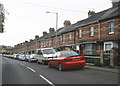
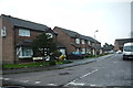
3
Houses on Forton Rd
These ex council houses are on the Forton Rd at the top of King Alfred's Drive.
Image: © Nigel Mykura
Taken: 31 Dec 2015
0.18 miles
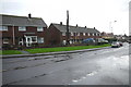
4
The approach drive to the Lordsleaze Hotel, Chard
Image: © David Medcalf
Taken: 22 Apr 2017
0.21 miles
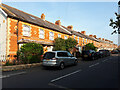
5
Russell Pope Avenue
Russell Pope Avenue is a residential street consisting mainly of semi detached houses. It is just off Henderson Drive which is off the Forton Rd the B3162.
Image: © Nigel Mykura
Taken: 31 Dec 2015
0.22 miles