IMAGES TAKEN NEAR TO
Commercial Row, CHARD, TA20 2FB
Introduction
This page details the photographs taken nearby to Commercial Row, TA20 2FB by members of the Geograph project.
The Geograph project started in 2005 with the aim of publishing, organising and preserving representative images for every square kilometre of Great Britain, Ireland and the Isle of Man.

There are currently over 7.5m images from over14,400 individuals and you can help contribute to the project by visiting https://www.geograph.org.uk
Image Map
Images are licensed for reuse under creativecommons.org/licenses/by-sa/2.0
Notes
- Clicking on the map will re-center to the selected point.
- The higher the marker number, the further away the image location is from the centre of the postcode.
Image Listing (107 Images Found)
Images are licensed for reuse under creativecommons.org/licenses/by-sa/2.0
Image
Details
Distance
1
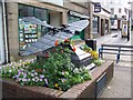
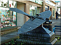
Stringfellows Aeroplane, Chard
On the High Street is a 7/8 scale sized replica of a plane built by John Stringfellow and flown in Chard in 1848.
Image: © Maigheach-gheal
Taken: 16 Aug 2009
0.01 miles
2
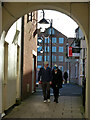
Passageway in Chard town centre
The former Holyrood Lace Mill is seen beyond.
Image: © Chris Allen
Taken: 26 Dec 2013
0.02 miles
3
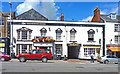
The Phoenix, Chard
This pub and inn used to be called The George. The style of architecture would suggest it was built in the late 1700s. It would have been a coaching inn, and the large doorway would have been for carriages and horses to access stables at the back.
Image: © mike smith
Taken: 6 Aug 2013
0.02 miles
4
Monument to John Stringfellow in Chard
The monument is a model of the first powered aircraft in the world, whose flight was achieved when John Stringfellow's steam powered plane flew in 1848 near Chard
Image: © David Smith
Taken: 20 Aug 2019
0.02 miles
5
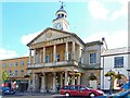
The Guildhall, Chard
The Guildhall is a Grade II* Listed Building in the centre of the town that dates back to 1837 and was formerly the Corn Exchange. The Guildhall houses the offices of Chard Town Council, but it is also a community building for a wide range of activities.
Image: © mike smith
Taken: 6 Aug 2013
0.02 miles
6
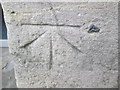
Ordnance Survey 1GL Bolt
This OS Bolt can be found on the front of the Town Hall/Guildhall. It marks a point 363.3ft above mean sea level.
Image: © Adrian Dust
Taken: 29 Mar 2015
0.02 miles
7
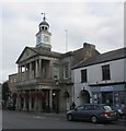
The Town Hall, Chard
Dates from 1834 https://historicengland.org.uk/listing/the-list/list-entry/1197456
Image: © Jonathan Thacker
Taken: 18 Sep 2018
0.02 miles
8
Bronze model of the first craft to achieve 'powered flight'
This statue/sculpture in Chard is a bronze model of the first device to achieve 'powered flight' in 1848. Designed by John Stringfellow of Chard (1799-1883). However, modern authors are inclined to state that the flight was neither sustained or controlled and did not count as being a true flight in the meaning of the word.
Image: © Chris Allen
Taken: 26 Dec 2013
0.02 miles
9
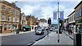
Fore Street, Chard
The wide main street of this market town.
Image: © Jonathan Billinger
Taken: 9 Sep 2022
0.02 miles
10
Guildhall at Christmas - Chard
The Guildhall, Grade II listed and built as a Corn Exchange in 1843, now decorated with Christmas lights on a cold bleak afternoon in December.
Image: © Sarah Smith
Taken: 6 Dec 2010
0.02 miles