IMAGES TAKEN NEAR TO
Henson Park, CHARD, TA20 1NJ
Introduction
This page details the photographs taken nearby to Henson Park, TA20 1NJ by members of the Geograph project.
The Geograph project started in 2005 with the aim of publishing, organising and preserving representative images for every square kilometre of Great Britain, Ireland and the Isle of Man.

There are currently over 7.5m images from over14,400 individuals and you can help contribute to the project by visiting https://www.geograph.org.uk
Image Map
Images are licensed for reuse under creativecommons.org/licenses/by-sa/2.0
Notes
- Clicking on the map will re-center to the selected point.
- The higher the marker number, the further away the image location is from the centre of the postcode.
Image Listing (12 Images Found)
Images are licensed for reuse under creativecommons.org/licenses/by-sa/2.0
Image
Details
Distance
1
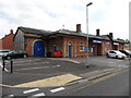
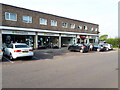
Former Central Railway Station, Chard
Now occupied by The Original Factory Shop. The scene a decade ago: Image
Image: © Roger Cornfoot
Taken: 6 Jul 2016
0.06 miles
2
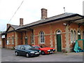
Chard Central Station
How can a town the size and importance of Chard have no railway? This was the station building, built in 1866, the year the Taunton-Chard line opened - full architectural details at http://webapp1.somerset.gov.uk/her/details.asp?prn=58207 . The station is now used by an international shipping company who seem happy for those interested in the building to have a look around.
Image: © Derek Harper
Taken: 21 Sep 2006
0.07 miles
5
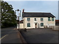
Furnham Inn, Furnham Road
A Grade II Listed public house, now permanently closed.
Image: © Vieve Forward
Taken: 18 Apr 2019
0.17 miles
6
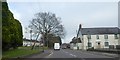
Former inn, Furnham, Chard
Formerly the Furnham Inn; listed grade II https://britishlistedbuildings.co.uk/101280618-furnham-inn-including-range-of-outbuildings-to-east-chard-town
Image: © David Smith
Taken: 30 Dec 2019
0.18 miles
10
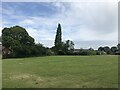
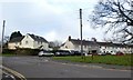
Stringfellow Park
Despite the name, this is just an area of cut grass monoculture. There are no facilities, play areas or gardens that you would normally associate with a park.
Image: © don cload
Taken: 24 Jun 2021
0.20 miles