IMAGES TAKEN NEAR TO
Woodside Walk, CHARD, TA20 1FZ
Introduction
This page details the photographs taken nearby to Woodside Walk, TA20 1FZ by members of the Geograph project.
The Geograph project started in 2005 with the aim of publishing, organising and preserving representative images for every square kilometre of Great Britain, Ireland and the Isle of Man.

There are currently over 7.5m images from over14,400 individuals and you can help contribute to the project by visiting https://www.geograph.org.uk
Image Map
Images are licensed for reuse under creativecommons.org/licenses/by-sa/2.0
Notes
- Clicking on the map will re-center to the selected point.
- The higher the marker number, the further away the image location is from the centre of the postcode.
Image Listing (8 Images Found)
Images are licensed for reuse under creativecommons.org/licenses/by-sa/2.0
Image
Details
Distance
1
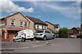
Houses in Caraway Close
Mainly detached modern brick built three and four bedroom houses on this quiet residential housing estate cul de sac on the east side of Chard.
Image: © Nigel Mykura
Taken: 26 May 2017
0.12 miles
4
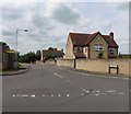
Houses in Heron Close, Chard
The herons may be close, because these houses are near to Chard Reservoir
Image: © David Smith
Taken: 30 Dec 2019
0.16 miles
5
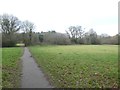
Knapweed Meadow, Chard Reservoir nature reserve
The main entrance path to the reserve
Image: © David Smith
Taken: 30 Dec 2019
0.18 miles
6
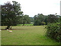
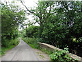
Parkland near Oaklands House
A view from a track north of Oaklands House on the outskirts of Chard.
Image: © Derek Harper
Taken: 21 Sep 2006
0.18 miles
7
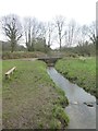
Stream in the nature reserve, Chard Reservoir
Image: © David Smith
Taken: 30 Dec 2019
0.22 miles
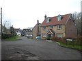
8
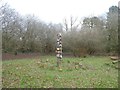
A place for gathering, Chard Reservoir nature reserve
One of the features to encourage young people to explore the nature reserve
Image: © David Smith
Taken: 30 Dec 2019
0.24 miles