IMAGES TAKEN NEAR TO
Druids Walk, CHARD, TA20 1BN
Introduction
This page details the photographs taken nearby to Druids Walk, TA20 1BN by members of the Geograph project.
The Geograph project started in 2005 with the aim of publishing, organising and preserving representative images for every square kilometre of Great Britain, Ireland and the Isle of Man.

There are currently over 7.5m images from over14,400 individuals and you can help contribute to the project by visiting https://www.geograph.org.uk
Image Map
Images are licensed for reuse under creativecommons.org/licenses/by-sa/2.0
Notes
- Clicking on the map will re-center to the selected point.
- The higher the marker number, the further away the image location is from the centre of the postcode.
Image Listing (1 Images Found)
Images are licensed for reuse under creativecommons.org/licenses/by-sa/2.0
Image
Details
Distance
1
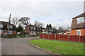
Houses in Furzehill, Chard
Furzehill consists of semi-detached houses probably built in the 1950's. There are some newer houses in the side street on the left which is Websters Way.
Image: © Nigel Mykura
Taken: 12 Mar 2017
0.20 miles