IMAGES TAKEN NEAR TO
Furnham Road, CHARD, TA20 1BE
Introduction
This page details the photographs taken nearby to Furnham Road, TA20 1BE by members of the Geograph project.
The Geograph project started in 2005 with the aim of publishing, organising and preserving representative images for every square kilometre of Great Britain, Ireland and the Isle of Man.

There are currently over 7.5m images from over14,400 individuals and you can help contribute to the project by visiting https://www.geograph.org.uk
Image Map
Images are licensed for reuse under creativecommons.org/licenses/by-sa/2.0
Notes
- Clicking on the map will re-center to the selected point.
- The higher the marker number, the further away the image location is from the centre of the postcode.
Image Listing (5 Images Found)
Images are licensed for reuse under creativecommons.org/licenses/by-sa/2.0
Image
Details
Distance
1
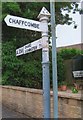
Direction Sign - Signpost by the A358, Furnham Road, Chard Town parish
Pyramid finial - 2 arms; Somerset SCC pyramid by the A358, in parish of Chard Town (South Somerset District), opposite junction with Chaffcombe Road and old Tollhouse: SO.CHA02 Image
Surveyed
Milestone Society National ID: SO_ST3309
Image: © Milestone Society
Taken: Unknown
0.02 miles
2
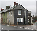
Old Toll House by Ilminster Road, Chard
Toll House, No. 108, Ilminster Road at junction with Chaffcombe Road.
Somerset HER.
HER number: 45124 https://www.heritagegateway.org.uk/Gateway/Results_Single.aspx?uid=45124&resourceID=100
Surveyed
Milestone Society National ID: SO.CHA02
Image: © Alan Rosevear
Taken: 16 Jan 2008
0.02 miles
4
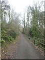
Cycle Path, NCN33, the Stop Line Way
Access track from a minor road in Chard to the former railway line
Image: © David Smith
Taken: 30 Dec 2019
0.21 miles
5
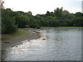
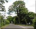
Chard Reservoir
The former reservoir and some of the surrounding land is now a nature reserve. The reservoir was built in 1842 to provide water for the nearby Chard Canal, and so became redundant in 1868 when the canal closed.
Image: © Derek Harper
Taken: 21 Sep 2006
0.24 miles