IMAGES TAKEN NEAR TO
Horton, ILMINSTER, TA19 9QU
Introduction
This page details the photographs taken nearby to TA19 9QU by members of the Geograph project.
The Geograph project started in 2005 with the aim of publishing, organising and preserving representative images for every square kilometre of Great Britain, Ireland and the Isle of Man.

There are currently over 7.5m images from over14,400 individuals and you can help contribute to the project by visiting https://www.geograph.org.uk
Image Map
Images are licensed for reuse under creativecommons.org/licenses/by-sa/2.0
Notes
- Clicking on the map will re-center to the selected point.
- The higher the marker number, the further away the image location is from the centre of the postcode.
Image Listing (30 Images Found)
Images are licensed for reuse under creativecommons.org/licenses/by-sa/2.0
Image
Details
Distance
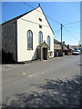
1
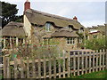
Thatched cottage on Forest Mill Lane
Image: © Roger Cornfoot
Taken: 18 Nov 2015
0.04 miles
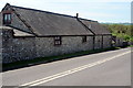
2
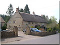
Thatched cottage, Pound Road, Horton
On the northwest edge of the village.
Image: © Derek Harper
Taken: 22 Apr 2006
0.07 miles
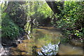
3
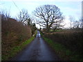
A bridge in Forest Mill Lane, Horton
Runs over a small tributary of the River Ding.
Image: © Anthony Vosper
Taken: 20 Jan 2014
0.11 miles
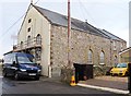
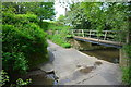
7
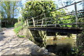
Footbridge over the ford on Paull's Lane
Image: © Philip Jeffrey
Taken: 7 May 2013
0.13 miles
9
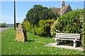
Bench and memorial at Horton crossroads
Image: © Philip Jeffrey
Taken: 7 May 2013
0.13 miles
10
Broadway Ford
This ford is found on Paull's Lane in Broadway.
Image: © John Walton
Taken: 23 May 2016
0.14 miles