IMAGES TAKEN NEAR TO
Holway House Park, Station Road, ILMINSTER, TA19 9PP
Introduction
This page details the photographs taken nearby to Holway House Park, Station Road, TA19 9PP by members of the Geograph project.
The Geograph project started in 2005 with the aim of publishing, organising and preserving representative images for every square kilometre of Great Britain, Ireland and the Isle of Man.

There are currently over 7.5m images from over14,400 individuals and you can help contribute to the project by visiting https://www.geograph.org.uk
Image Map
Images are licensed for reuse under creativecommons.org/licenses/by-sa/2.0
Notes
- Clicking on the map will re-center to the selected point.
- The higher the marker number, the further away the image location is from the centre of the postcode.
Image Listing (14 Images Found)
Images are licensed for reuse under creativecommons.org/licenses/by-sa/2.0
Image
Details
Distance
1
Old Toll House, Station Road, Ilminster
Toll House, No. 138, Station Road, Ilminster.
Grade II listed.
List Entry Number: 1298249 https://historicengland.org.uk/listing/the-list/list-entry/1298249
Surveyed
Milestone Society National ID: SO.ILM02
Image: © Alan Rosevear
Taken: Unknown
0.07 miles
2
A gridded gate
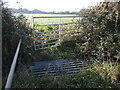
Oddly, a farm field gate is protected by a cattle grid as it crosses a small ditch, bounded by the main road.
Image: © Neil Owen
Taken: 9 Dec 2022
0.07 miles
3
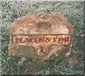
Old Milestone by the B3168, Slape West, Ilminster
Metal plate attached to stone post by the B3168 (was A303), in parish of Ilminster (South Somerset District), Slape West, opposite Haselwell Tollhouse, on grass verge, on South side of road. Ilminster iron plate, erected by the Ilminster turnpike trust in the 19th century.
Inscription reads:-
: (TAUNTON / 11) : : ILMINSTER / 1 :
Somerset HER listed.
HER number: 14182 https://www.heritagegateway.org.uk/Gateway/Results_Single.aspx?uid=14182&resourceID=100
Milestone Society National ID: SO_IMHO01
Image: © SA Melligan
Taken: 18 Dec 2002
0.07 miles
5
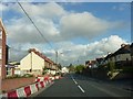
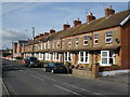
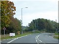
B3168 Station Road, Ilminster
Entering Crewkerne from the west.
Image: © Steve Barnes
Taken: 1 Sep 2009
0.11 miles
6
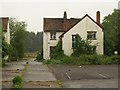
Derelict houses near Hort Bridge
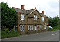
These houses are beside the site of the Somerset Cattle Breeding Centre and the Horlicks cheese factory and dairy, now demolished.
Image: © Derek Harper
Taken: 13 May 2009
0.14 miles
8
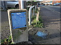
Good information in the main
A Wessex Water marker for the mains.
Image: © Neil Owen
Taken: 9 Dec 2022
0.18 miles
9
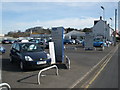
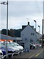
Brakes Motor Company, Ilminster
Ford dealership, in Station Road.
Image: © Roger Cornfoot
Taken: 16 Feb 2009
0.19 miles
10
Hort Bridge, Ilminster
The stone has a sign welcoming visitors to Ilminster, and the bridge crosses the River Isle
Image: © David Smith
Taken: 2 Oct 2014
0.20 miles