IMAGES TAKEN NEAR TO
Wood Road, ILMINSTER, TA19 9LP
Introduction
This page details the photographs taken nearby to Wood Road, TA19 9LP by members of the Geograph project.
The Geograph project started in 2005 with the aim of publishing, organising and preserving representative images for every square kilometre of Great Britain, Ireland and the Isle of Man.

There are currently over 7.5m images from over14,400 individuals and you can help contribute to the project by visiting https://www.geograph.org.uk
Image Map (Loading...)


Getting Data...Please wait
Leaflet Map data © OpenStreetMap
Images are licensed for reuse under creativecommons.org/licenses/by-sa/2.0
Notes
- Clicking on the map will re-center to the selected point.
- The higher the marker number, the further away the image location is from the centre of the postcode.
Image Listing (17 Images Found)
Images are licensed for reuse under creativecommons.org/licenses/by-sa/2.0
Image
Details
Distance
1
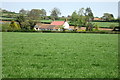
Arable field with Forest Farm in the distance
Image: © Philip Jeffrey
Taken: 7 May 2013
0.08 miles
2
Tree and established hedge in a field by Roche Farm
Image: © Philip Jeffrey
Taken: 7 May 2013
0.12 miles
3
Field north of New House Farm
West of Wood Road, which follows the field boundary.
Image: © Christine Johnstone
Taken: 30 Jun 2014
0.14 miles
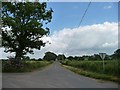
4

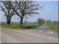
Road Junction Near Hastings
This is the "T" junction on the minor road between Windmill Hill and Newhouse Farm. The road on the left goes off towards Hastings.
Image: © Nigel Mykura
Taken: 22 Sep 2022
0.15 miles
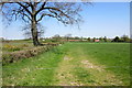
5
Wood Road
Running north from New House Farm, towards Windmill Hill.
Image: © Christine Johnstone
Taken: 30 Jun 2014
0.16 miles
6
Junction at Newhouse Farm
Junction on the straight drove roads on the north-east side of the Blackdown Hills.
Image: © Derek Harper
Taken: 22 Apr 2006
0.17 miles
7
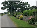
Floral display outside the garden of New House Farm
On the west side of the road from Broadway and Horton to Bickenhall.
Image: © Christine Johnstone
Taken: 30 Jun 2014
0.18 miles
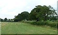
8

Field by Hastings Cross
A view from a gate on Hastings Cross, the lane between Wood Road and Southtown, and also the name of a nearby junction. The land slopes away to a tributary of the Cad Brook.
Image: © Derek Harper
Taken: 12 May 2012
0.18 miles
9
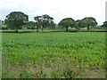
Maize field, north-east of New House Farm
Not doing so well at the margin.
Image: © Christine Johnstone
Taken: 30 Jun 2014
0.18 miles
10
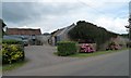
Older buildings at New House Farm
Bigger and newer buildings lie behind these.
Image: © Christine Johnstone
Taken: 30 Jun 2014
0.19 miles