IMAGES TAKEN NEAR TO
Hare Lane, ILMINSTER, TA19 9LN
Introduction
This page details the photographs taken nearby to Hare Lane, TA19 9LN by members of the Geograph project.
The Geograph project started in 2005 with the aim of publishing, organising and preserving representative images for every square kilometre of Great Britain, Ireland and the Isle of Man.

There are currently over 7.5m images from over14,400 individuals and you can help contribute to the project by visiting https://www.geograph.org.uk
Image Map
Images are licensed for reuse under creativecommons.org/licenses/by-sa/2.0
Notes
- Clicking on the map will re-center to the selected point.
- The higher the marker number, the further away the image location is from the centre of the postcode.
Image Listing (7 Images Found)
Images are licensed for reuse under creativecommons.org/licenses/by-sa/2.0
Image
Details
Distance
1
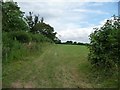
Field entrance, west side, Pound Road
At the edge of Broadway village, this little triangular field could get built on one day.
Image: © Christine Johnstone
Taken: 30 Jun 2014
0.14 miles
2

Entrance to Chaffey's Plot, Pound Road, Broadway
A rectangular field which now contains a large detached house.
Image: © Christine Johnstone
Taken: 30 Jun 2014
0.14 miles
3

End of the 30 mph limit, Pound Road
At the north-western edge of Broadway.
Image: © Christine Johnstone
Taken: 30 Jun 2014
0.15 miles
4

Slow, crossroads in 75 yards on Pound Road
Coming into Broadway from the north-west.
Image: © Christine Johnstone
Taken: 30 Jun 2014
0.17 miles

6
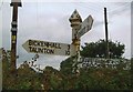
Direction Sign - Signpost on the crossroads at Broadway Pound
Pyramid finial - 3 arms, 1 missing; Somerset SCC pyramid by the UC road, in parish of Broadway (South Somerset District), Broadway Pound on the north side of the crossroads of Hare Lane, Pound Road and Broadway Road.
surveyed
Milestone Society National ID: SO_ST3115
Image: © Milestone Society
Taken: Unknown
0.19 miles
7
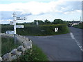
Road sign and crossroads, near Broadway
Image: © Ruth Sharville
Taken: 29 May 2007
0.22 miles