IMAGES TAKEN NEAR TO
Letham Court, ILMINSTER, TA19 9JZ
Introduction
This page details the photographs taken nearby to Letham Court, TA19 9JZ by members of the Geograph project.
The Geograph project started in 2005 with the aim of publishing, organising and preserving representative images for every square kilometre of Great Britain, Ireland and the Isle of Man.

There are currently over 7.5m images from over14,400 individuals and you can help contribute to the project by visiting https://www.geograph.org.uk
Image Map (Loading...)


Getting Data...Please wait
Leaflet Map data © OpenStreetMap
Images are licensed for reuse under creativecommons.org/licenses/by-sa/2.0
Notes
- Clicking on the map will re-center to the selected point.
- The higher the marker number, the further away the image location is from the centre of the postcode.
Image Listing (108 Images Found)
Images are licensed for reuse under creativecommons.org/licenses/by-sa/2.0
Image
Details
Distance
1
Ilminster: the Bell Inn
Looking across High Street from the top of North Street.
Image: © Chris Downer
Taken: 24 Jan 2009
0.04 miles
2
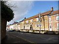
Ilminster: westward from East Street, past Market Hall
Little has changed since 1960 - except of course the road vehicles.
Image: © Ben Brooksbank
Taken: 24 Apr 1960
0.05 miles
3
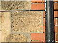
Odd carvings on Strawberry Bank
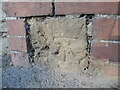
Terraced houses flank the Bell Inn, with the endmost house bearing some faded carved stonework. In the nineteenth century this corner would have had a benchmark, but it has since been lost and another mark made on the Sunday school nearby. Are these marks the old cutmark or are they some initials of the builder/owner? See Image] for a wider view.
Image: © Neil Owen
Taken: 9 Dec 2022
0.06 miles
4
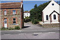
Strawberry Bank, Ilminster
A row of houses and a pub in the middle, opposite the old Sunday school. The end house of the terrace bears a stone with faint carvings - see Image
Image: © Neil Owen
Taken: 9 Dec 2022
0.06 miles
5
An old mark for a school
There used to be a Sunday School here in the past on Butts since the late nineteenth century but it has been demolished. Toad Hall now stands in its place, close to the ambulance station. On an entrance pier is a benchmark from the twentieth century. See https://www.bench-marks.org.uk/bm181237 for the entry in the Benchmark Database.
Image: © Neil Owen
Taken: 9 Dec 2022
0.06 miles
6
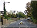
Old Road, Ilminster
Heading north out of Ilminster, the road is largely reduced to a footpath up to the top of Beacon Hill and is considerably steeper than New Road ImageThereafter it becomes a well used farm track.
Image: © Andy Pearce
Taken: 19 Aug 2009
0.06 miles
7
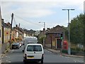
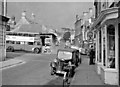
Traffic in Ilminster High Street
The building on the right is a gospel hall; hopefully it is soundproofed against traffic noise
Image: © David Smith
Taken: 2 Oct 2014
0.07 miles
8
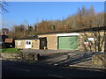
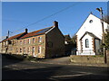
Ilminster ambulance station
The little station occupies a site that was previously a Sunday school.
Image: © Neil Owen
Taken: 9 Dec 2022
0.08 miles
9
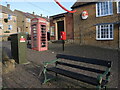
Between West Street and High Street
A sliver of land between the two main roads is occupied by some municipal items, the Gospel Hall and a large Santa. For sake of completion, the telephone box does have a telephone in it.
Image: © Neil Owen
Taken: 9 Dec 2022
0.08 miles
10
Ilminster, Butts
Simply called "Butts", this is the eastwards extension of Ilminster High Street
Image: © David Smith
Taken: 2 Oct 2014
0.08 miles