IMAGES TAKEN NEAR TO
Higher Beacon, ILMINSTER, TA19 9AJ
Introduction
This page details the photographs taken nearby to Higher Beacon, TA19 9AJ by members of the Geograph project.
The Geograph project started in 2005 with the aim of publishing, organising and preserving representative images for every square kilometre of Great Britain, Ireland and the Isle of Man.

There are currently over 7.5m images from over14,400 individuals and you can help contribute to the project by visiting https://www.geograph.org.uk
Image Map (Loading...)


Getting Data...Please wait
Leaflet Map data © OpenStreetMap
Images are licensed for reuse under creativecommons.org/licenses/by-sa/2.0
Notes
- Clicking on the map will re-center to the selected point.
- The higher the marker number, the further away the image location is from the centre of the postcode.
Image Listing (32 Images Found)
Images are licensed for reuse under creativecommons.org/licenses/by-sa/2.0
Image
Details
Distance
1
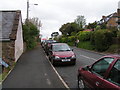
New Road, Ilminster
The B3168 going north out of Ilminster. The road goes round Beacon Hill and is not as steep as Old Road further to the east.
Image: © Andy Pearce
Taken: 19 Aug 2009
0.09 miles
2

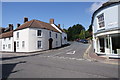
Junction of Station Road and New Road, Ilminster
Image: © Roger Cornfoot
Taken: 16 Feb 2009
0.12 miles
4
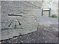
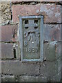
Benchmark by Speke Close
A cutmark, as listed in the Benchmark Database: https://www.bench-marks.org.uk/bm120042 , on Station Road close to the junction. See Image] for a wider view.
Image: © Neil Owen
Taken: 9 Dec 2022
0.14 miles
5
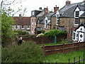
Entrance to Speke Close
Joining to Station Road is Speke Close, which only leads to a short cul-de-sac. On the junction by the telegraph pole is a benchmark - see Image
Image: © Neil Owen
Taken: 9 Dec 2022
0.14 miles
6
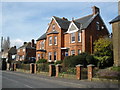
Woodleigh guest house, Station Road, Ilminster
Image: © Roger Cornfoot
Taken: 16 Feb 2009
0.15 miles
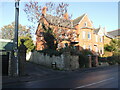
7
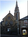
The old Wesleyan Methodist church
Ilminster had a Methodist church on this spot since 1777, but this building was founded in 1887. It is described as being in Vigorous Decorated Gothic Revival style and, along with the associated hall, are Grade II listed.
It served until 2008 when it went under the hammer and has become part of the town's arts facilities. However, the unkempt vegetation around the entrance suggests it is not used regularly.
Image: © Neil Owen
Taken: 9 Dec 2022
0.15 miles
9
Ilminster, West Street flush bracket
A flush bracket set in the wall of the old Brewery Inn. See https://www.bench-marks.org.uk/bm2864 for the entry in the Benchmark Database and Image] for a wider view.
Image: © Neil Owen
Taken: 9 Dec 2022
0.16 miles
10
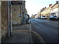
Along West Street
A view westwards along Ilminster's main road, with a flush bracket set into the wall close to the poles - the only one left in Ilminster. See Image
Image: © Neil Owen
Taken: 9 Dec 2022
0.16 miles